What the Stuhleck sees
The highest peak of the Fischbacher Alpen has a road up to the hut and a car park on the summit. 360 bearings, 800 kilometres, 3,215 contest logs, plus the laser scan for the hut next door — and a horizon none of the five sites before it has. Only Germany lies half behind the Rax.
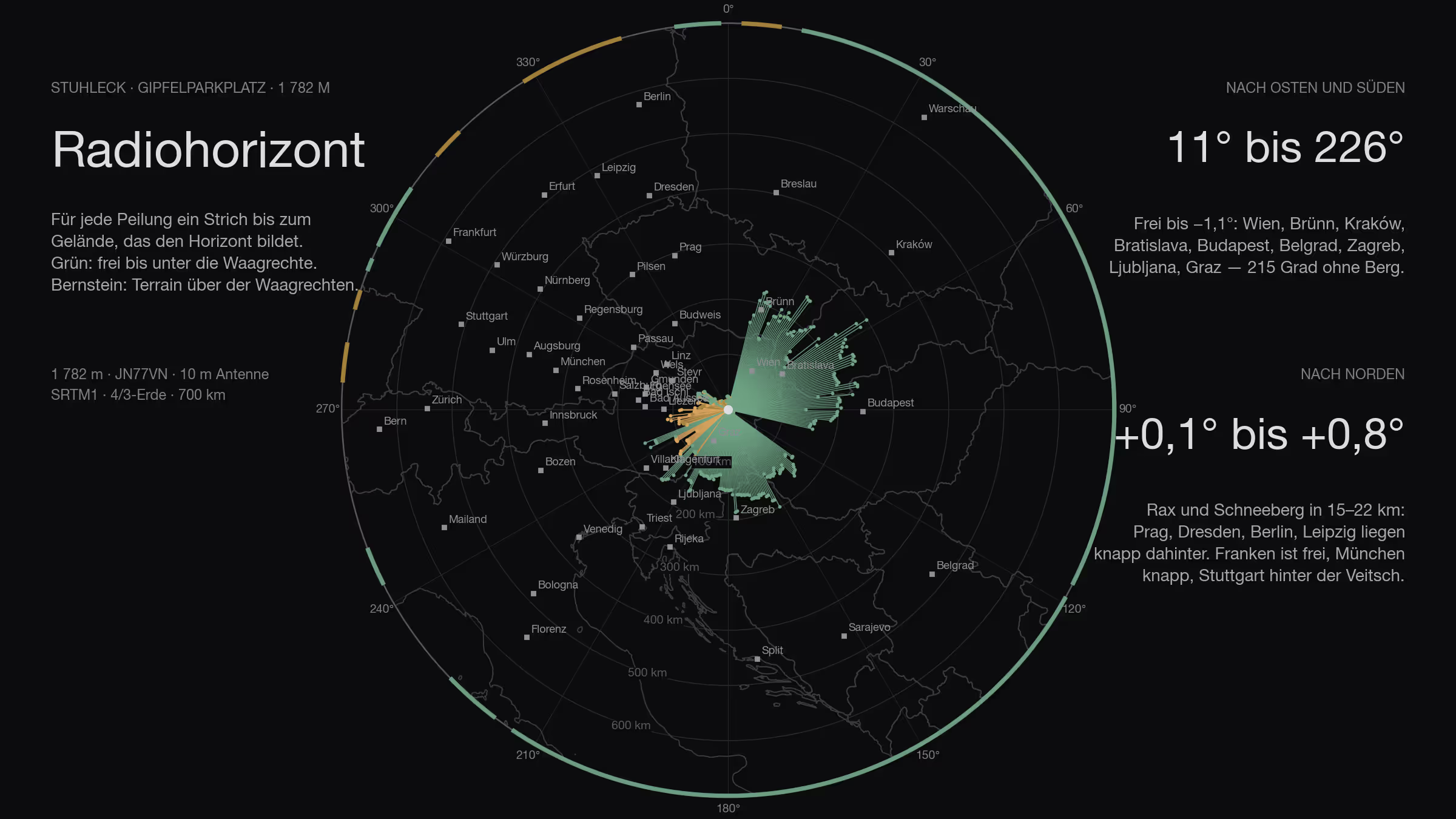
Five sites have been calculated, and all five had the same question: how far into Germany. The Stuhleck turns the question round. At 1,782 metres it is the highest peak of the Fischbacher Alpen, it stands on the eastern edge of the Alps, and east of it, all the way to the Tatra, nothing stands higher. On the summit is the Alois-Günther-Haus, next to it a gravel car park with a road leading up to it — the site where you do not have to walk, this time right at the top. In the IARU contest 2025 a station made 155 contacts from here with five watts and a ten-element Yagi. That was the reason to calculate it.
How
The method is the same as for the five sites before: SRTM terrain model, one ray per degree, ten-metre antenna, 4/3 earth, 500 kilometres out, the names of the obstacles from Wikipedia; plus the second step from the Feuerkogel post, the 3,215 contest logs of the IARU contests 2024 and 2025 recalculated for this site. New is the third step: for the last hundred metres — the hut, the car park, the summit cross — the laser-scan surface model of the Austrian Federal Office of Metrology and Surveying, one-metre grid, half a metre accurate. The terrain model knows no roof; the laser scan knows every one.
The reference point is the car park by the hut, 47.57444 N / 15.79055 E, locator JN77VN. The laser scan gives 1,779 metres for the car park and 1,786 for the ridge of the hut.
All the way round
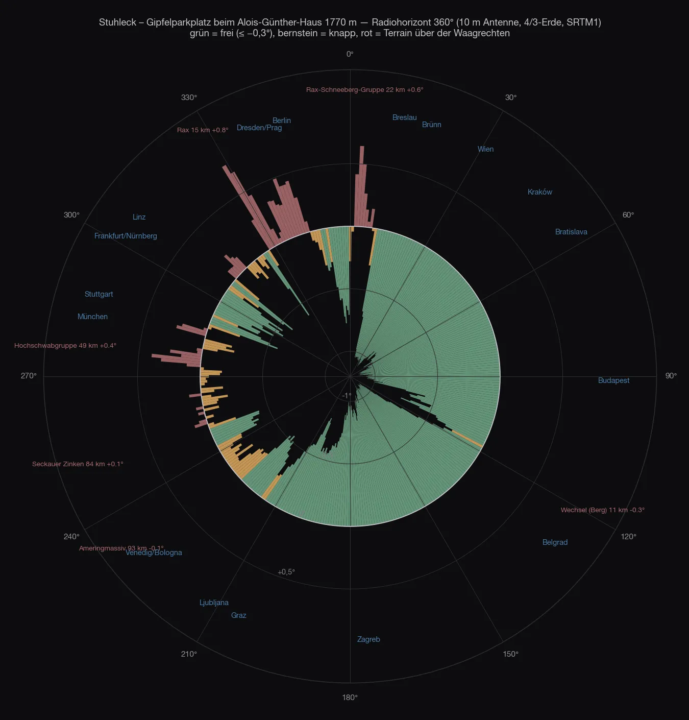
From 11° to 226° the horizon is clear, 215 degrees in one piece, and not by a whisker: −0.3° to −1.1° below the horizontal. What forms it stands far away — the Altvater at 298 kilometres, the Greater Fatra at 286, the Low Tatra at 322, the Papuk at 269, the Snežnik at 243. Vienna lies at −1.04°, Bratislava at −1.07°, Budapest at −1.05°, Belgrade at −1.11°, Zagreb at −0.88°, Ljubljana at −0.52°, Graz at −0.75°. That is not a window, that is half a circle.
| Direction | What sets the horizon | Distance | Angle |
|---|---|---|---|
| 11–117° | Altvater, Greater Fatra, Low Tatra, Bakony | 150–320 km | −1.1…−0.3° |
| 119–226° | Papuk, Medvednica, Pohorje, Snežnik, Karawanks | 100–270 km | −1.1…−0.3° |
| 227–273° | Amering, Gleinalpe, Zirbitzkogel, Wildfeld, Trenchtling | 40–120 km | −0.3…+0.1° |
| 274–280° | Hochschwab | 49 km | +0.0…+0.4° |
| 285–290° | Hohe Veitsch | 30 km | +0.0…+0.2° |
| 291–305° | Dürrenstein, Tonion, Ötscher | 35–60 km | −0.6…−0.3° |
| 311–316° | Schneealpe | 21 km | +0.1…+0.2° |
| 328–344° | Rax | 15 km | +0.0…+0.8° |
| 2–8° | Schneeberg | 22 km | +0.1…+0.6° |
The other half is not closed, it is just not clear. Four mountains stand to the north-west and north barely above the horizontal: the Hochschwab at +0.4°, the Veitsch at +0.2°, the Schneealpe at +0.2° and the Rax at +0.8° — and the Schneeberg at +0.6° to the north. Behind them lie Salzburg (+0.25°), Stuttgart (+0.1°), Budweis, Prague and Dresden (+0.4° each), Leipzig (+0.5°), Berlin (+0.2°), Poznań (+0.1°). Those are diffraction losses of three to eight decibels, not a wall — on the Feuerkogel the Traunstein at +0.27° was the same case. In between remains the one German window: 291° to 305°, through between Veitsch and Schneealpe, Nuremberg −0.46°, Regensburg −0.54°, Würzburg −0.53°, Passau −0.49°. Munich lies at 283° and −0.20°, just clear.
The site
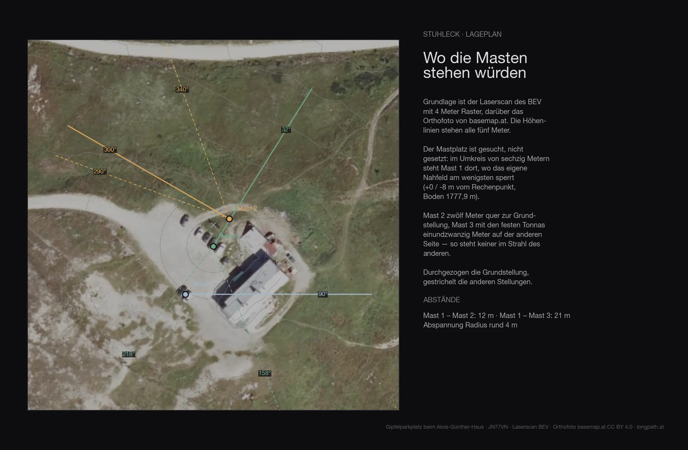
The terrain of the first 136 metres around the site comes from the Austrian lidar survey on a four-metre grid — trees, buildings and knolls included. The ground at the mast is at 1777.9 metres.
| Antenna height | Directions blocked by the near field |
|---|---|
| 6 m | 65° |
| 8 m | 56° |
| 10 m | none |
| 12 m | none |
| 15 m | none |
With ten metres of mast the site is free of its own near field in all 360 directions. Whatever is blocked from here is blocked by distant terrain, not by the site.
Within 500 kilometres
Whoever wants to know what works on VHF without restriction gets a short list here. Clear, below −0.3°: everything from 11° to 117° — Wrocław, Brno, Ostrava, Kraków, Žilina, Bratislava, Košice, Győr, Budapest, Debrecen, Szeged, that is Moravia, southern Poland, Slovakia, Hungary and western Ukraine; everything from 119° to 226° — Timișoara, Novi Sad, Belgrade, Pécs, Sarajevo, Split, Zagreb, Rijeka, Ancona, Graz, Ljubljana, Bologna; the window 291° to 305° into Franconia; and 352° to 1° to Szczecin. Marginal, between −0.3° and 0°: the Po valley from 227° to 242° (Trieste, Klagenfurt, Venice, Verona), Munich, Linz, Erfurt, Pilsen. Not clear, but below +0.8°: Salzburg, Stuttgart, Budweis, Prague, Dresden, Leipzig, Berlin, Poznań. Above +0.8° there is nothing. Of the 1,274 logs within 500 kilometres, 1,035 have the horizon below the horizontal, 215 lie at 0° to +0.5°, 24 at +0.5° to +0.8°, not a single one above.
Two sites, one no-go
After the first sheet came a second mark: not the dome, but the meadow south of the hut, 34 metres from its southern corner, 153 from the top station — site B. And a condition that had not been in the calculation before: no transmitting towards the chairlift, and not 180 degrees turned either, because the back lobe of a Yagi should not point at the lift. So both were calculated again, with the same laser scan and the same rule.
The rule, in degrees: top station and line as they appear from the Yagi mast, plus 17 degrees — half the beam of the 12JXX2 — on either side. From the dome (A) that is 215° to 262°, turned 35° to 82°. From the meadow (B), from where the lift lies due west, 244° to 288° and 64° to 108°. No main beam may enter, none of the quads’ either; with their 69 degrees they have their own, wider margin.
What lies in the red sectors differs between the two sites. From A it is Italy forward: Trieste, Venice, Bologna, Verona, Milan, 281 Italian logs, plus Slovenia — 298 stations the Yagi otherwise reaches. Backward it is Poland, Slovakia, Ukraine and Czechia: Ostrava, Kraków, Žilina, Bratislava, Košice, Lviv, 267. From B the west lies forward: Munich, Innsbruck, Salzburg, Zurich, Milan, 157 stations, 49 of them German; backward Hungary, eastern Slovakia, Romania, Ukraine — Košice, Budapest, Debrecen, Cluj, 119.
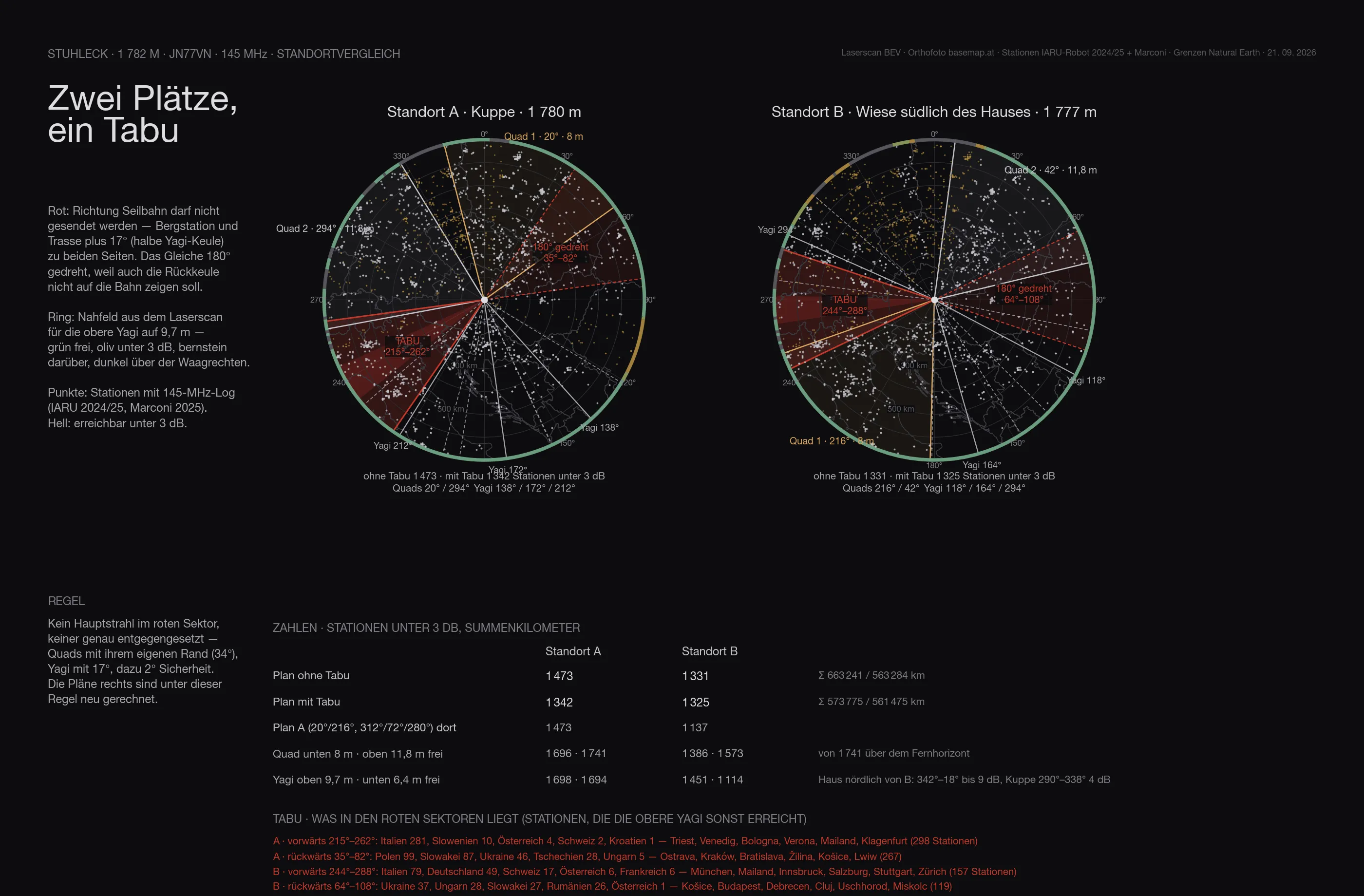
Recalculated under the rule, the plan looks different. On the dome, quad 2 goes from 216° to 294° — Nuremberg, Regensburg, Passau, Munich, Linz: the German window thus gets the fixed antenna on top at 11.8 metres —, quad 1 stays on 20°, and the stack has its three positions in the south, 138°, 172°, 212°: Belgrade, Zagreb, Split, Rijeka, Ljubljana, Trieste. 1,342 stations under three decibels, 131 fewer than without the rule. On the meadow the hut stands due north, its ridge nine metres above the ground: the lower quad at eight metres sees nothing from 343° to 18°, the upper one loses four decibels there, the upper Yagi nine, and the lower Yagi is blind from 259° to 45° — thirteen decibels. The best plan turns the quads around: 216° below for Italy, 42° above over the hut towards Brno and Kraków, the stack on 118°, 164°, 294°. 1,325 stations.
Without the no-go the dome is clearly the better site, 1,473 against 1,331. With it the two come almost level — A loses its Italian direction, B loses the west instead, and the north to the hut. What the number does not show: on the meadow the stack’s lower Yagi is blind to north and west, leaving a single Yagi with two and a half decibels less, and everything German has to go over the upper quad. The dome remains the site where all four antennas work.
While calculating, a second question came up: Germany is the country with the most stations — does the quad belong there, or a fixed Yagi? The answer turned the plan around once more; it is in the next section.
The site plan with both sites has the distances to hut, top station and pylons for mast 1, mast 2 and the point on the meadow.
The choice
The brief was clear: every long contact is better than a near one, but most QSOs are to be had in Germany, and many small stations sit there — being able to reach them matters more than the last kilometre. So one more calculation, with a counting rule that reflects that: a station counts if an antenna has it above the far horizon, under three decibels of near-field loss and with the required gain in the beam — six dBi up to 300 kilometres, from there three decibels per hundred kilometres. Small stations, under fifty QSOs in their best contest, need four decibels more, big ones three less. For Germany the DARC contest lists joined the IARU logs: 1,070 stations within 750 kilometres, 567 of them small. Then 42 combinations: two quads or two Yagis fixed, one stack fixed, quad and Yagi mixed — against a Yagi stack, a quad stack or a single antenna on the rotator, ANJO’s 14-element Yagi as a candidate too.
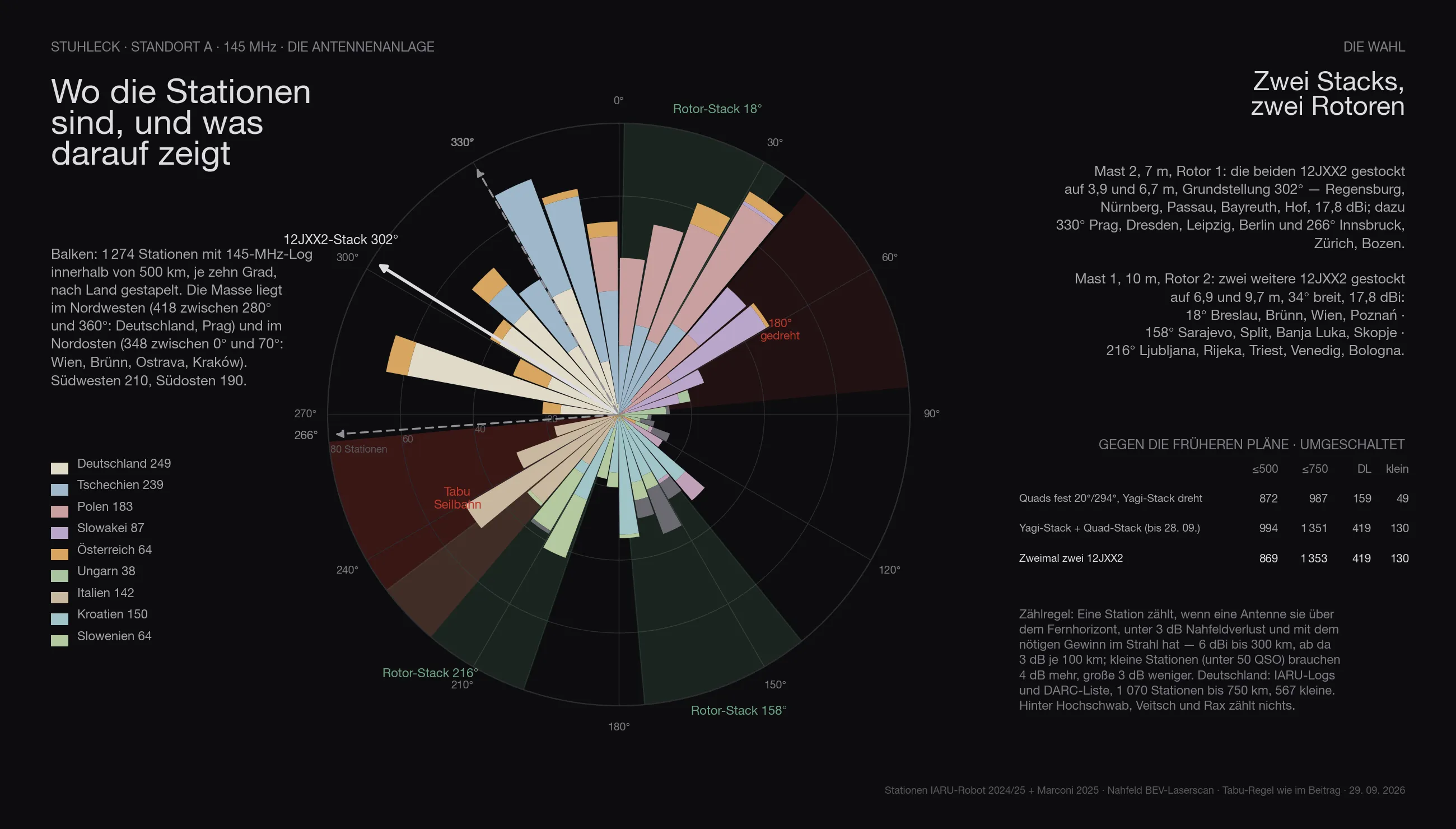
The result turns the first plan around. The two 12JXX2 go stacked on mast 2, rest position 302° — Regensburg, Nuremberg, Passau, Bayreuth, Hof, at 17.8 dBi, Munich at the beam’s edge with thirteen, which is enough for two hundred kilometres. The two quads go stacked on the rotator of mast 1, 69 degrees wide, 14.5 dBi, three positions: 20° Wrocław, Brno, Ostrava, Kraków, Vienna — the second big block, 405 stations; 108° Budapest, Belgrade, Hungary, Serbia; 200° Zagreb, Rijeka, Ljubljana, Trieste, Venice, as far as the no-go allows. The near range lies in two broad blocks that a wide antenna serves without constant turning; the far range needs the gain only the stack has — and Germany needs both.
And the Yagi stack gets a rotator of its own. The rest position stays 302°, but two more positions fetch what no antenna reached with gain before: 330° Prague, Dresden, Leipzig, Berlin — Germany’s north-east behind the Rax — and 266° Innsbruck, Zurich, Bolzano, hard against the no-go edge. That is the biggest single gain of the whole calculation: 994 stations within 500 kilometres and 1,351 within 750, against 968 and 1,205 with the stack fixed and 872 and 987 for the first plan. In Germany 419 of the 1,070, 130 of them small — the first plan had 159 and 49, because a quad with twelve dBi no longer reaches a small station beyond four hundred kilometres.
The quads separated into two directions, back to back on the rotator, were the other idea — dropped, and the power says why. With the power going to all antennas at once, each system gets its share: two systems half each, three a third each. Two quads in two directions then have twelve dBi each with a third, the quad stack 14.5 with half — 4.3 decibels per direction, and the counting rule turns that into 520 instead of 871 stations within 750 kilometres. And both are weaker than the installation that transmits on one system at a time and listens on the others: all the power into whichever stack is on gives the 1,351. Transmit on one antenna, listen on all — that is the rule that follows from the numbers. Whoever nonetheless always transmits on all and only switches the listening gets different best positions with half power per stack: the Yagi stack stays at rest on 302° but goes to 18° (Kraków, Žilina) and 86° (Košice, Budapest) instead of Saxony and Switzerland, because the far range behind the Rax is out of reach at half power anyway; the quads on 20°, 136°, 200°. That gives 854 and 950 stations, Germany 226, 64 of them small — a third less than with the switch, in Germany almost half. If the Yagi stack always stays on 302° and only the quad stack turns (20°, 116°, 200°), it is 783 and 817 — Germany the same, the seventy missing are Kraków and Košice with the Yagi gain. An unequal divider, two thirds for the Yagi stack, would give 1,010 within 750 kilometres and 262 German.
The masts are shorter than thought: ten metres for the quads, seven and a half for the Yagis. On the dome that changes nothing — the laser scan recalculated for every height gives the same numbers at eight metres as at thirteen, because in every direction only the hut stands in the near field, and no position points there for long. What counts is the stack, not the height: a mast with only one antenna costs a hundred stations in the near range. Mast 1 on the dome, twelve metres from the summit cross, carries the quads at 6.4 and 9.7 metres; mast 2, twelve metres further north-west, the Yagis at 4.0 and 7.5 — from the quad mast the Yagi mast lies at 328°, outside every quad position, and from the Yagi mast the quads lie at 148°, behind the stack at rest. The Yagi mast is guyed at 3.3 metres, below rotator and lower Yagi, so that no wire runs through the elements.
The site plan as PDF, revision 5 has the installation as it stands: all three masts with coordinates, heights, directions and guy radii, the distances to the hut, summit cross, cable-car station and vehicle, the three coax runs with their lengths, and the sources.
Update, 29 September: two Yagis on mast 1 as well. Instead of the quad stack, a second 12JXX2 stack goes on the rotator of mast 1, at 6.4 and 9.7 metres, as on the Feuerkogel. The lobe gets narrower, 34 instead of 69 degrees, with 3.3 decibels more. The three positions, calculated with the same rule and outside the no-go sector: 18° Wrocław, Brno, Vienna, Poznań; 158° Sarajevo, Split, Banja Luka, Skopje; 216° Ljubljana, Rijeka, Trieste, Venice, Bologna. Split between both stacks that makes 948 stations instead of 894, Germany 316 as before, and 330,000 instead of 270,000 kilometres — the gain reaches further. Switched it is 1,308 instead of 1,331: at close range the wide quad gets more, 1,006 against 869 within 500 kilometres, the Yagis get the distance instead. The sheet above and the 3D scene already show both Yagi stacks; the text above still describes the plan with the quads.
That leaves the question the swap raises: would the quad stack on mast 1 not have brought more? At 69 degrees it is twice as wide as the 12JXX2 stack with 34 — in exchange it has 3.3 decibels less gain. Because both large antennas sit on rotators and only the Tonnas are fixed, what counts is not what one heading covers at a given moment but what the antenna reaches across the whole contest.
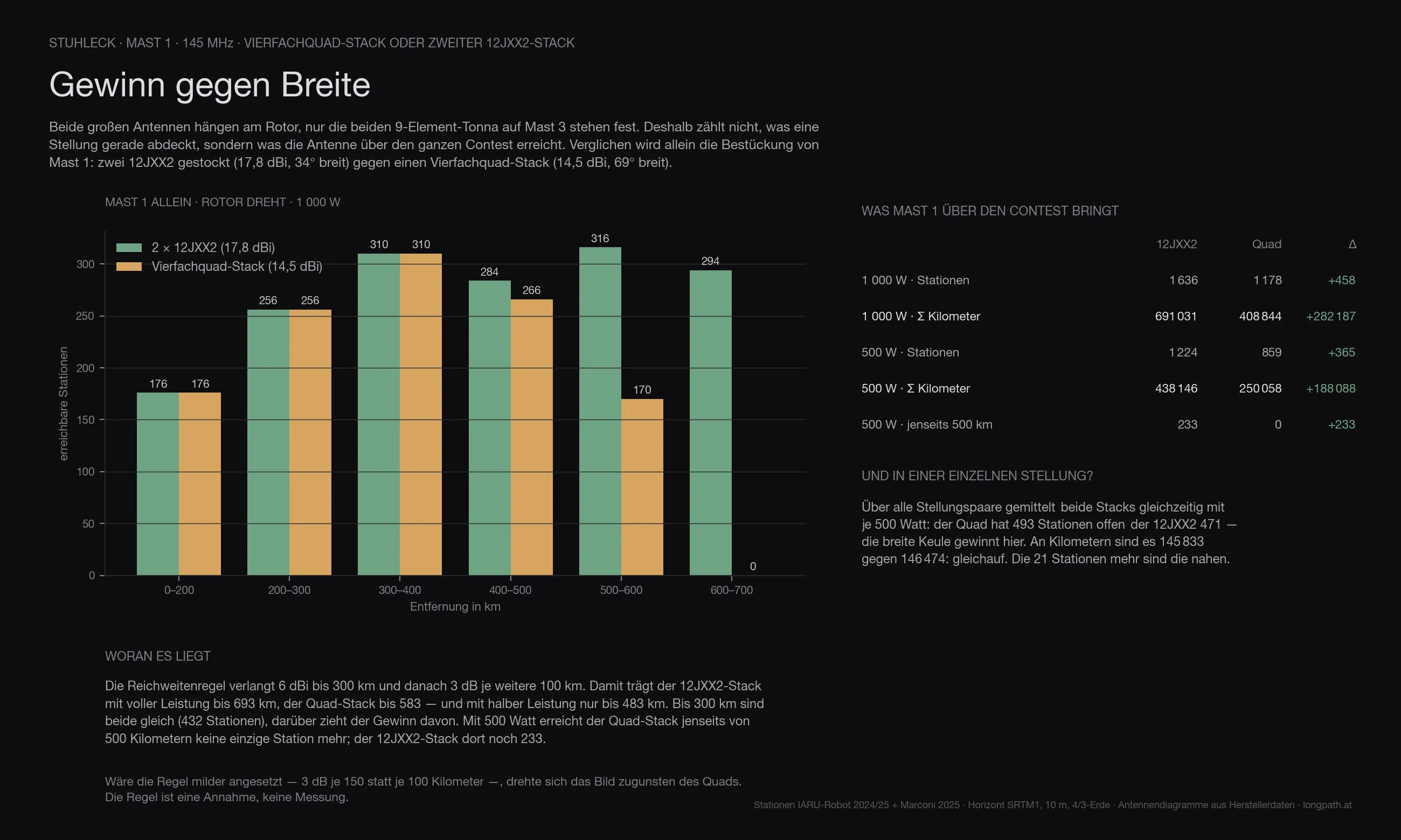
| Mast 1, rotator turning | 2 × 12JXX2 | quad stack | difference |
|---|---|---|---|
| 1 000 W · stations | 1 636 | 1 178 | +458 |
| 1 000 W · Σ kilometres | 691 031 | 408 844 | +282 187 |
| 500 W · stations | 1 224 | 859 | +365 |
| 500 W · Σ kilometres | 438 146 | 250 058 | +188 088 |
| 500 W · beyond 500 km | 233 | 0 | +233 |
Out to 300 kilometres the two are equal — 432 stations either way. There the gain is enough regardless. Beyond that the gain pulls ahead: the range rule asks for 6 dBi to 300 km and then 3 dB per further 100 km. That takes the 12JXX2 stack to 693 kilometres at full power, the quad to 583 — and at half power only to 483. At 500 watts the quad stack reaches not a single station beyond 500 kilometres, the 12JXX2 stack still 233.
Looked at one heading at a time it reads differently: averaged over all heading pairs the quad has 493 stations open, the 12JXX2 471 — the wider beam wins. In kilometres it is 145 833 against 146 474, level: the twenty-two extra stations are the near ones, and a VHF contest counts kilometres.
One caveat belongs with this: set the range rule more gently — 3 dB per 150 instead of per 100 kilometres — and the picture turns in favour of the quad. The rule is an assumption, not a measurement. For this site it changes little: what scores here are the long paths, and those the gain brings in.
Masts and guying
The installation stands on three masts. Mast 1 and mast 2 each carry two 12JXX2; the rotator stands on the ground and turns the whole mast, which runs through a top bearing. Boom and elements sweep a circle of 2.85 metres radius, and no guy may pass through it; so all guys hang below the lower Yagi. Mast 1, the rotator stack, is ten metres high, Yagis at 6.9 and 9.7 metres, guys at the top bearing at 6.4 and a second bearing at 3.3 metres, anchors five metres out, 47 metres of rope. The height has a reason: the laser scan shows that only from about ten metres does the stack look east over the Alpenhaus — 43 more stations in Hungary and Romania than at seven metres; twelve metres would add only 16. Mast 2, the Germany stack, does not need it: between 260 and 350 degrees every height from six to twelve metres is equally good, so seven metres, Yagis at 3.9 and 6.7 metres, top bearing at 3.4 metres, anchors three and a half metres out, 16 metres of rope. It is turned by hand, with a clamp and marks at the foot for 302°, 330° (Prague, Dresden, Berlin) and 266° (Munich, Innsbruck); mast 1 turns freely, except towards the cable car.
Mast 3 carries two 9-element Tonnas fixed on 24° — Wrocław, Brno, Ostrava, Kraków, Vienna, the largest block after Germany. It is seven metres high as well, without a rotator, the Tonnas at 3.9 and 6.7 metres, some 21 metres west of mast 1; it is guyed only once, at 6.3 metres just below the upper Tonna, three guys beside the boom, anchors five and a half metres out, 28 metres of rope. It is fed through a switch: rotator alone, Tonna alone, or both split. While stations are calling, the rotator runs at full power; over the whole contest the Tonna adds hardly any points, and split permanently it would cost a fifth. In quiet hours, at night or on Sunday morning, you switch to “both” and call in three directions at once: Germany, north-east and the rotator somewhere else, with on average some forty percent more stations in reach.
Masts 1 and 2 are 11.7 metres apart, mast 3 a good 21 metres from mast 1. No guy comes closer than 0.4 metres to a Yagi in any position of either rotator, and the guys of the masts stay more than six metres apart. The guys are plastic rope so they do not disturb the pattern. The car with the equipment stands at the west edge of the car park; along the ground, up the mast and with loop and reserve that is 40 metres of coax from mast 1, 35 from mast 2 and 50 from mast 3, with Ecoflex 15 so 1.0 to 1.5 dB.
Stuhleck and Feuerkogel
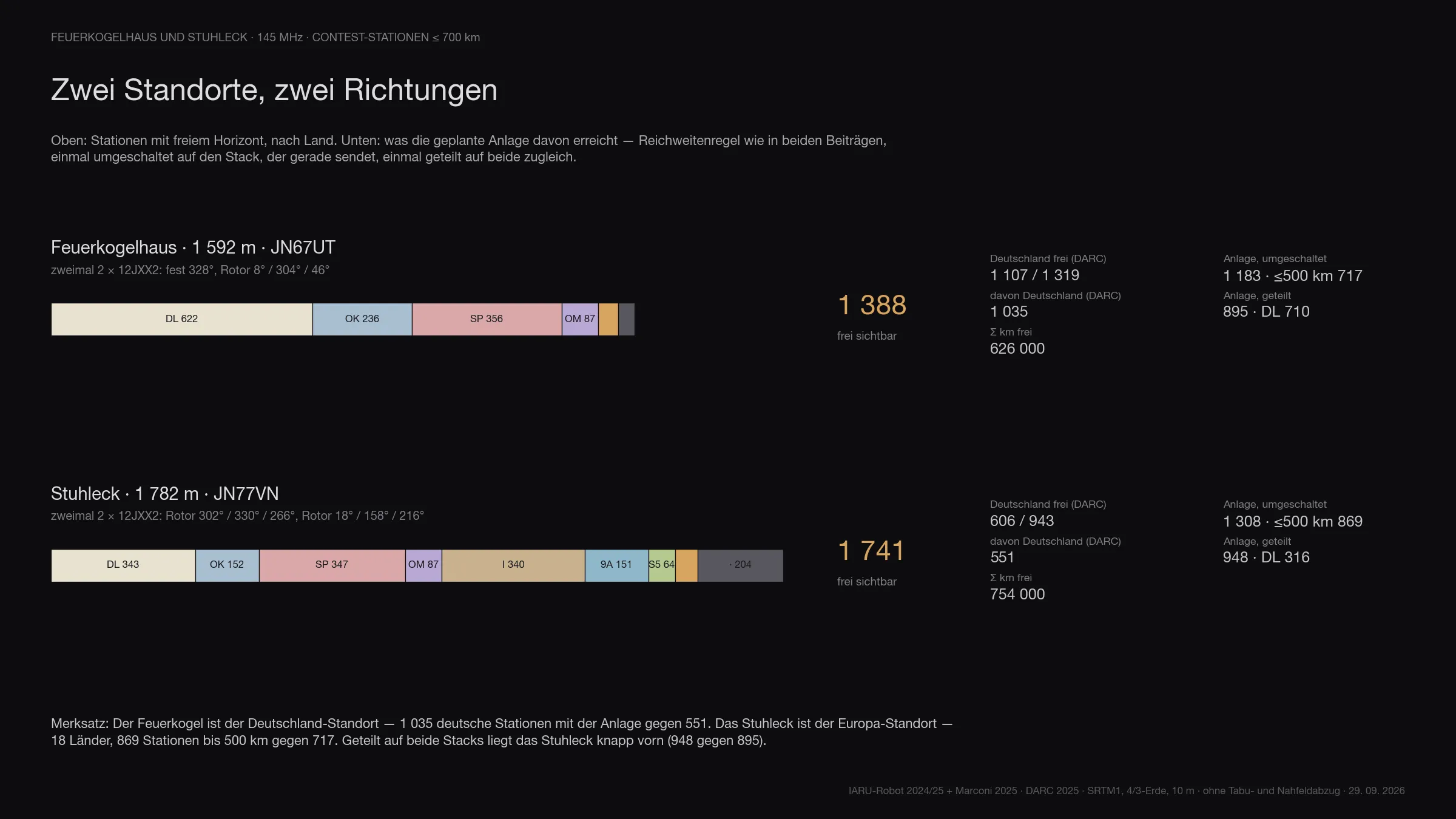
The installation for the Feuerkogel has now been calculated as well, two times two Yagis, one fixed on Germany, one on the rotator. That makes it possible to compare both sites, each with its own installation and the same rule:
| Stuhleck | Feuerkogelhaus | |
|---|---|---|
| Stations clear ≤ 700 km | 1,741 | 1,388 |
| Countries | 18 | 10 |
| Germany clear (DARC) | 606 of 943 | 1,107 of 1,319 |
| Installation, switched | 1,308 | 1,183 |
| of which within 500 km | 869 | 717 |
| of which Germany (DARC) | 551 | 1,035 |
| Installation, split | 948 | 895 |
| of which Germany (DARC) | 316 | 710 |
| Σ kilometres clear | 754,000 | 627,000 |
The Stuhleck has more stations, more countries and the better close range. With its installation the Feuerkogel reaches almost twice as many German stations, because no mountain stands in front of the German north there. Split between both stacks the Stuhleck is narrowly ahead, 948 against 895. Both installations are now two times two 12JXX2. Whoever collects German stations goes to the Feuerkogel; whoever collects countries and kilometres in the south and east goes to the Stuhleck.
The choice of site
In the end a contest counts kilometres. So once more both sites with the same installation, two times two 12JXX2, both stacks transmitting at once, one standing on Germany (Feuerkogel 328°, Stuhleck 302°). Counted is the sum of kilometres of all stations reached within 700 km, once with the rotator stack on its three best positions, once turned freely, the way a contest turns after cluster and skeds. For the Stuhleck also the variant without the no-go sector, in case the cable-car company allows transmitting towards the lift.
| Points (km) | Feuerkogel | Stuhleck with no-go | Stuhleck without no-go |
|---|---|---|---|
| half power per stack, rotator on 3 positions | 327,000 (845 stations) | 298,000 (869) | 322,000 (890) |
| half power per stack, rotator turned freely | 415,000 (1,051) | 437,000 (1,222) | 506,000 (1,357) |
| full power per stack, rotator on 3 positions | 543,000 (1,240) | 463,000 (1,182) | 497,000 (1,181) |
| full power per stack, rotator turned freely | 622,000 (1,375) | 681,000 (1,624) | 753,000 (1,738) |
The Feuerkogel wins only as long as the rotator stays on a few positions; then Germany carries everything. Once it turns, the Stuhleck is ahead, by 5 to 10 percent with the no-go sector and by a good 20 percent without, and the gap grows with power because far more stations are clear from the Stuhleck. Then there is the setup: an open dome with the car beside it, against masts squeezed next to the house between the path, the ramp and the drop. And the Plöckenstein, where OE5BGN operates, lies 107 kilometres from the Feuerkogel exactly in the direction of Prague and Berlin, and 195 kilometres from the Stuhleck behind the Rax. The choice is the Stuhleck.
The map
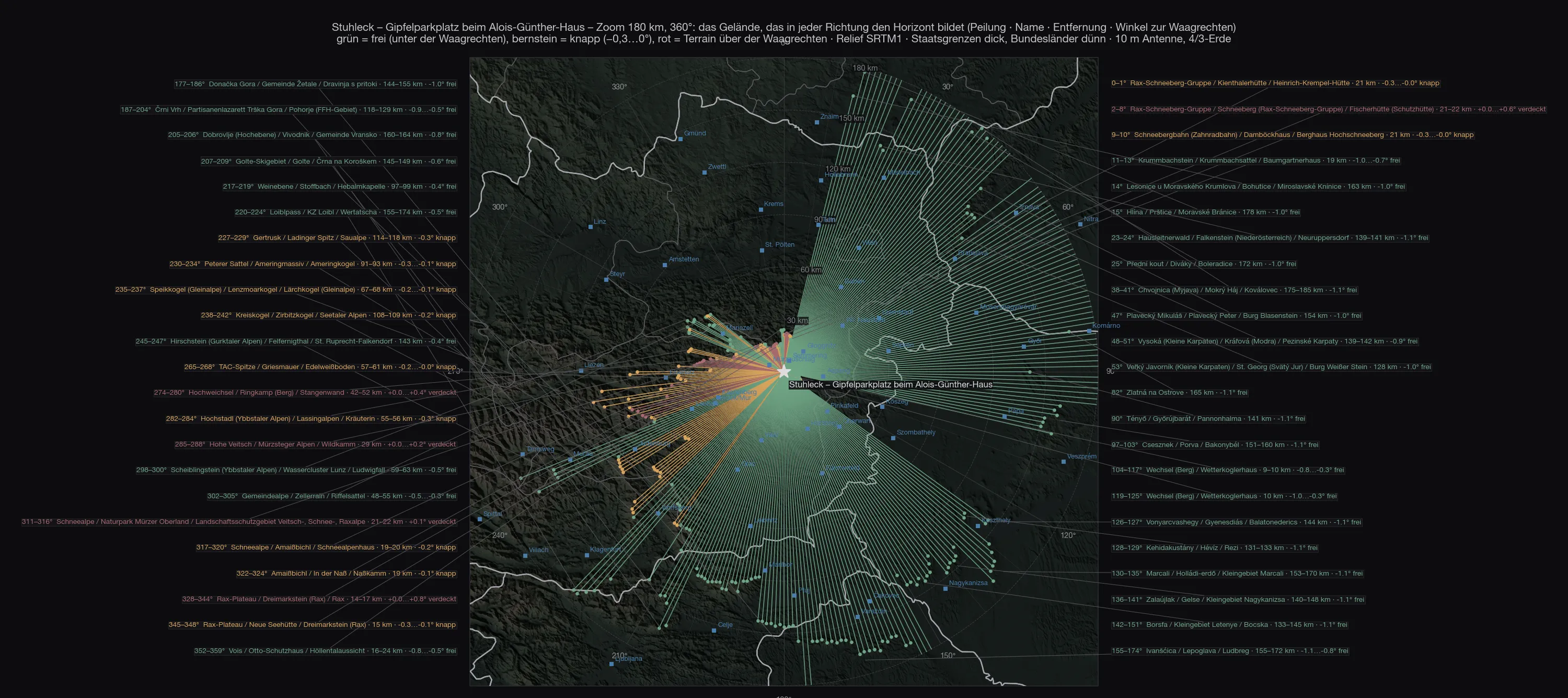
On the zoom you can see how unequal the lines are: to the east and south they run out of the map, to the north-west they end after fifteen to fifty kilometres at the Rax, the Schneealpe, the Veitsch, the Hochschwab.
Out to 700 kilometres
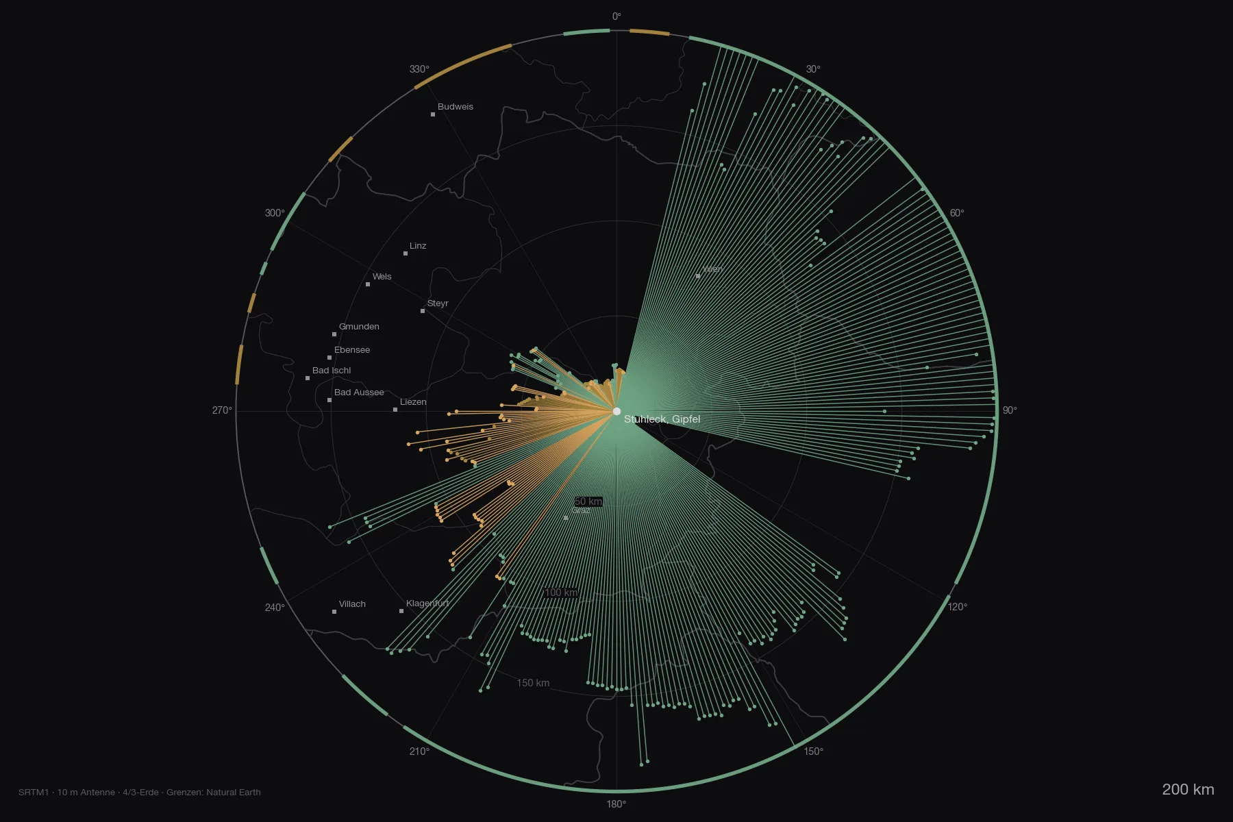
Both maps as PDF: zoom 180 km with the mountain names and overview 800 km with the numbered list — of the ranges all round only Schneeberg and Hochschwab rise above the horizontal, all the others form the horizon from below.
The stations
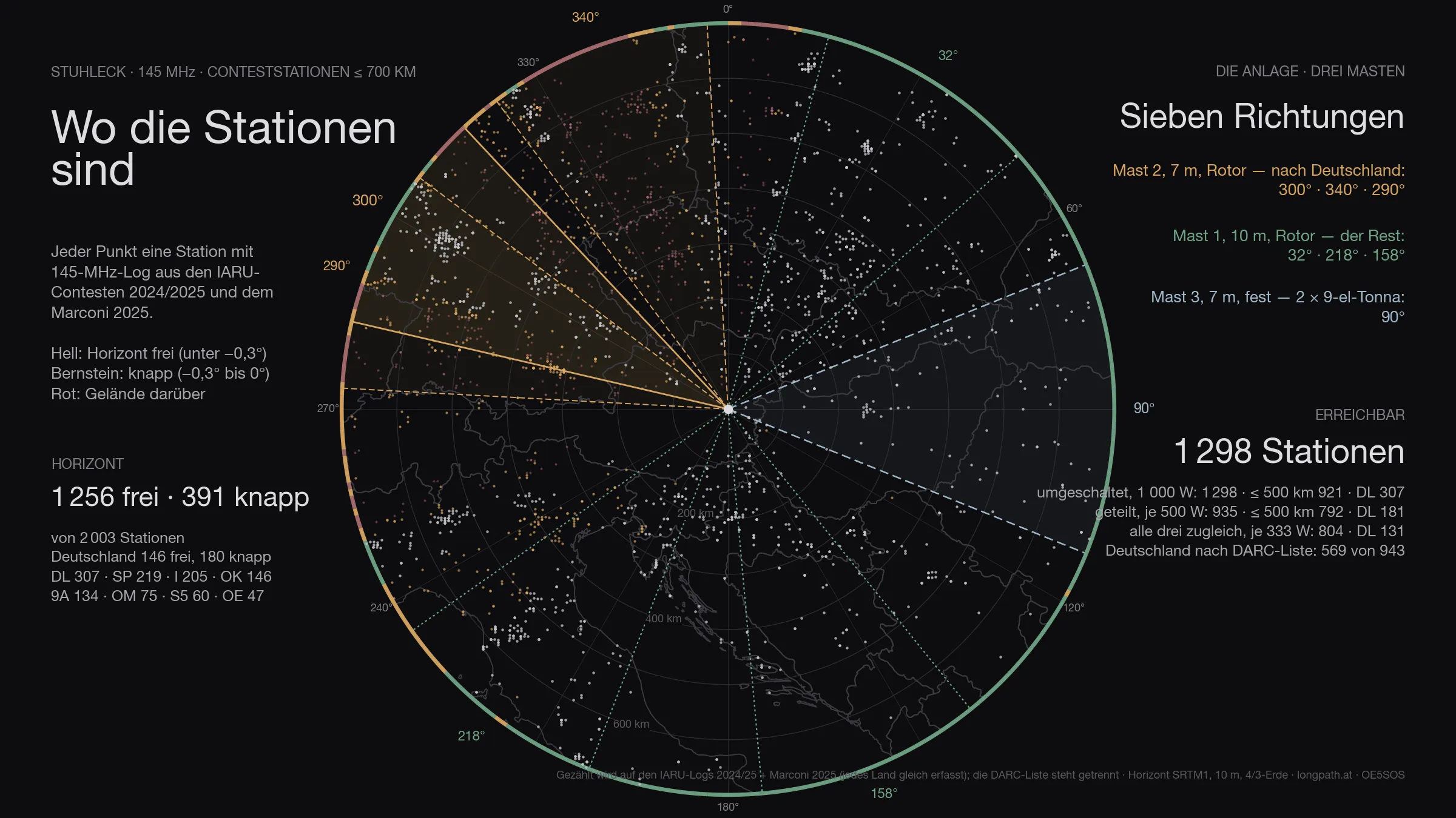
Of the 2 003 stations that appear in the logs within 700 kilometres, 1 647 are above the horizon — Germany 326 of 513. That is the ceiling: no antenna, however large, gets past it.
The figure has two halves. Genuinely clear — horizon more than three tenths of a degree below the horizontal — are 1 256 stations, 146 of them in Germany. The other 391 are marginal: between −0.3° and zero, in the grazing shadow of an edge. Something works there, but at a loss of three to eight decibels depending on the day. Both numbers are given, because only both together describe the site. Of the 248 degrees that are clear, 64 marginal degrees come on top.
The antennas
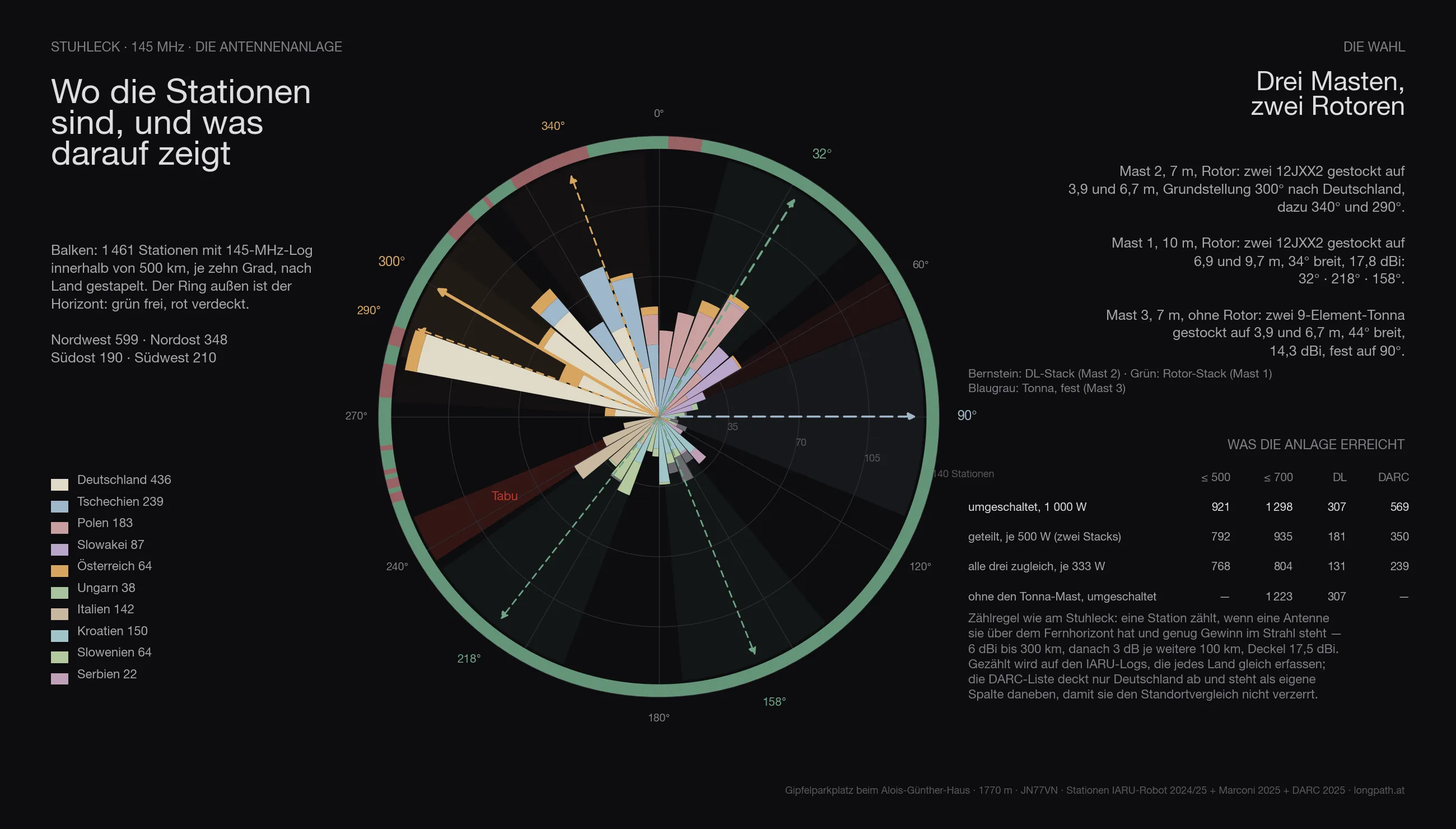
The same array is computed everywhere as the one on the Stuhleck, with three masts:
- Mast 2, 7 metres, rotator: two 12JXX2 stacked at 3.9 and 6.7 m — the stack that looks at Germany.
- Mast 1, 10 metres, rotator: two 12JXX2 stacked at 6.9 and 9.7 m, 34° wide, 17.8 dBi.
- Mast 3, 7 metres, no rotator: two stacked 9-element Tonnas at 3.9 and 6.7 m, 44° wide, 14.3 dBi — fixed on one heading.
The headings are not guessed but searched: for Stuhleck they come out at 300° / 340° / 290° for the DL stack, 32° / 218° / 158° for the rotator stack and 90° for the fixed Tonnas.
Feeding goes through a switch. With the full 1 000 watts on whichever system is being worked, the array reaches 1 549 stations across the contest (Germany 326, by the DARC list 569). Split across the two rotator stacks, 500 watts each, it is 1 157; with only three fixed headings per rotator 1 298; spread over all three systems at once only 804 — three directions cost more power than they gain in coverage. The Tonna mast alone adds 75 stations that would otherwise be missing.
In three dimensions
The orthophoto from basemap.at lies on the laser-scan terrain, one pixel is twenty centimetres, the masts, the quads and the stack are to scale. What the scene shows is not the view — that comes from the terrain model — but what stands in the first hundred and fifty metres: the hut, the car park, the summit cross, the dome — and 120 metres to the south-west the top station of the Steinbachalmbahn, a roofed structure of eighteen by seven metres on columns, eight metres high, with the two rope strands running down the valley over two pylons. Seen from the antennas its roof lies five to eight degrees below the horizontal; it stands in no sector’s way, and the “Bergstation” button shows that from the masts’ point of view. None of it is in the way. The scene shows the installation as it is finally planned — two stacks on two rotators, the Yagi stack at rest on Germany, plus the red sector; how that came about, the next two sections tell.
The comparison
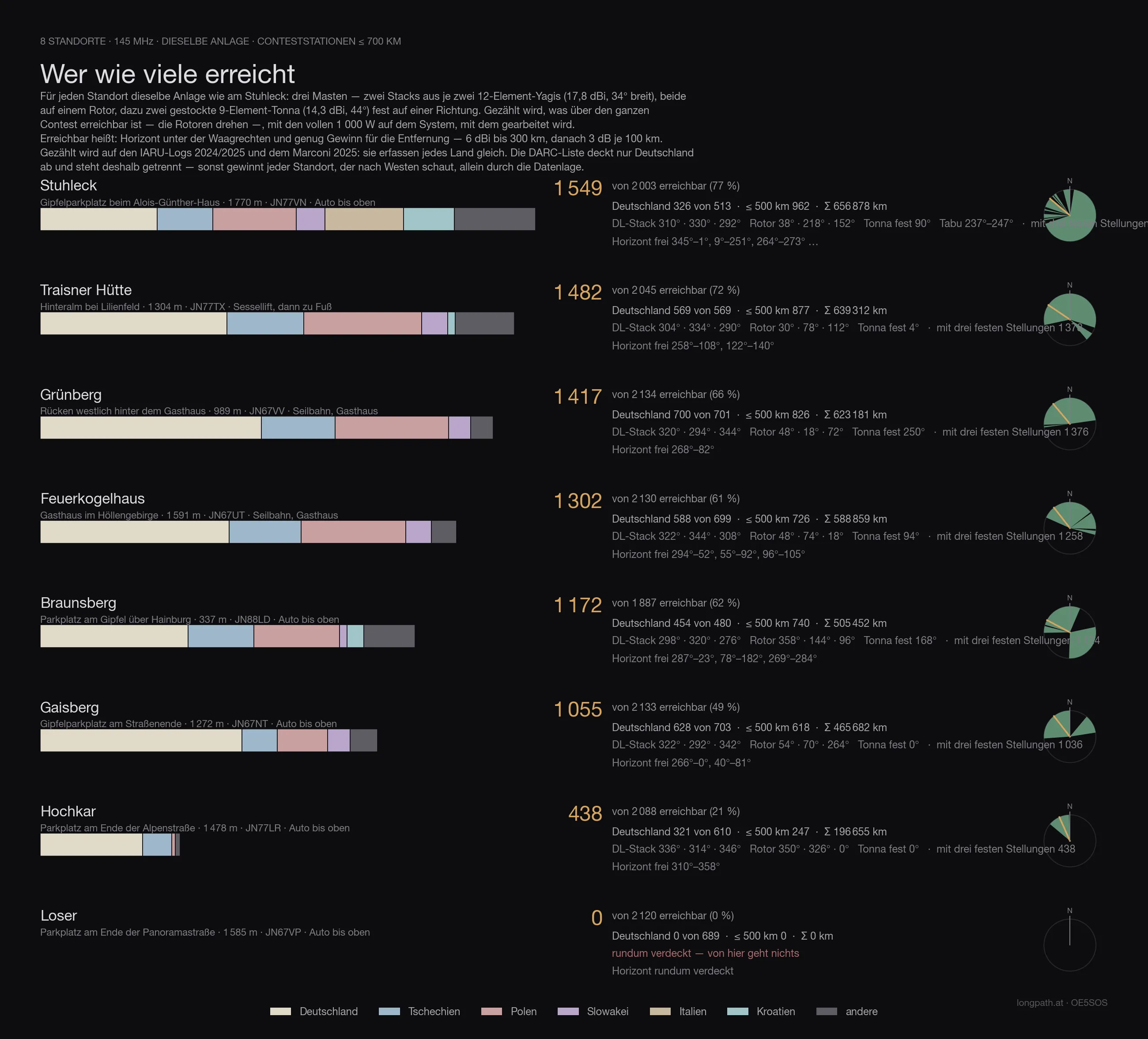
Every site in this series with the same array, the same counting rule and the same logs — only then are the numbers comparable. Reached means: horizon below the horizontal and enough gain for the distance (6 dBi to 300 km, then 3 dB per further 100 km), with 1 000 watts on whichever system is being worked. Both large antennas sit on rotators — so the count is what is reachable across the whole contest, not what one fixed heading covers.
The count runs on the IARU logs 2024/2025 and the Marconi 2025: they record every country alike. The DARC list covers Germany only — it sits in its own column, otherwise every site that looks west wins on the data alone.
| Site | reached | Germany | DARC list | ≤ 500 km | Access |
|---|---|---|---|---|---|
| Stuhleck · 1 770 m | 1 549 | 326 | 569 | 962 | drive to the top |
| Traisner Hütte · 1 304 m | 1 482 | 569 | 988 | 877 | chairlift, then on foot |
| Grünberg · 989 m | 1 417 | 700 | 1 271 | 826 | cable car, inn |
| Feuerkogelhaus · 1 591 m | 1 302 | 588 | 1 056 | 726 | cable car, inn |
| Braunsberg · 337 m | 1 172 | 454 | 814 | 740 | drive to the top |
| Gaisberg · 1 272 m | 1 055 | 628 | 1 199 | 618 | drive to the top |
| Hochkar · 1 478 m | 438 | 321 | 559 | 247 | drive to the top |
| Loser · 1 585 m | 0 | 0 | 0 | 0 | drive to the top |
Stuhleck therefore comes 1 of 8.
Anyone who knows the earlier articles in this series will find different numbers there: those were computed with the first line-up — one Yagi stack and one quad stack with a 69° beamwidth. Since the choice fell on two narrow 12JXX2 stacks, the order shifts: more gain and less width favours the sites whose stations bunch in one direction, and costs the ones that stand open all round. The fixed Tonnas on mast 3 win part of that width back.
The data
| Site | Stuhleck — Gipfelparkplatz beim Alois-Günther-Haus |
| Coordinates | 47,57444 N / 15,79055 O · 1 770 m · JN77VN |
| Access | road all the way up |
| Horizon clear | 345°–1°, 9°–251°, 264°–273°, 289°–310° … |
| Degrees clear / marginal / blocked | 248° / 64° / 48° |
| Stations ≤ 700 km | 1 256 clear, 391 marginal, of 2 003 |
| Germany (IARU) | 146 clear, 180 marginal, of 513 |
| Germany (DARC list) | 605 below the horizontal of 943 |
| Array | three masts · mast 1 10 m (2 × 12JXX2 at 6.9/9.7 m, rotator) · mast 2 7 m (2 × 12JXX2 at 3.9/6.7 m, rotator) · mast 3 7 m (2 × 9-el Tonna at 3.9/6.7 m, fixed) |
| Headings | DL-Stack 300° / 340° / 290° · Rotor-Stack 32° / 218° / 158° · Tonna fest 90° |
| switched · 1 000 W | 1 549 · ≤ 500 km 962 · DL 326 · with three fixed headings per rotator 1 298 |
| split · 500 W each | 1 157 · ≤ 500 km 932 · DL 202 |
| all three at once · 333 W each | 804 · ≤ 500 km 768 · DL 131 |
| without the Tonna mast | 1 223 instead of 1 298 |
| Σ kilometres | 656 878 km |
| strict count | only directions below −0.3°: 737 · ≤ 500 km 611 · DL 71 |
What it means
The Stuhleck has the widest horizon of any site in this series: 248 of 360 degrees lie more than three tenths of a degree below the horizontal, eighteen countries are clear, and you can drive to the spot. What is missing is Germany: Rax, Schneeberg, Schneealpe and Hochschwab stand between 274° and 344° at up to +0.8°, and behind them sits the mass of German stations.
For a contest that means: the Stuhleck wins on the sum — Italy, Croatia, Slovenia, Hungary, Slovakia, Poland, Czechia — and loses to Grünberg, Gaisberg and Feuerkogel as soon as only Germany counts. With the three-mast array and 1 000 watts on whichever system is being worked it reaches 1 549 stations, 962 of them within 500 kilometres — with only three fixed headings per rotator it would be 1 298.
Caveat
The terrain model has a thirty-metre grid; for the summit itself the laser scan at one metre stands against it, for the rest the standard atmosphere. The station counts are logs, not stations, and two years old. Whether you may drive up to the hut, no map says; the road is a forest road, and the hut belongs to the Alpine Club. And the Steinbachalmbahn ends 120 metres south-west of the summit cross — whether it runs in September is a question for the lift company, not for the terrain model.
What the calculation says: the Stuhleck is the mountain from which you see Europe. Germany you see from others.
73 · OE5SOS