What the Gaisberg sees
The Gaisberg is the mountain you simply drive up: 1,272 metres, ten kilometres from Salzburg, a car park at the end of the road, and the view goes straight into Bavaria. I calculated it like the others — 360 bearings, the laser-scan model for the last two hundred metres, the contest logs on top. The view is good. The site is not.
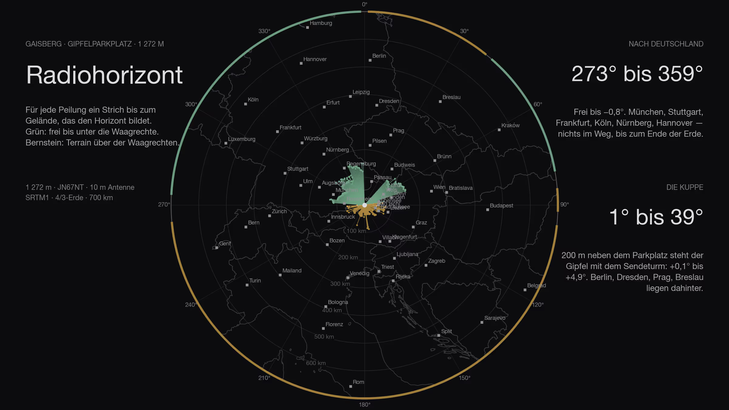
The Gaisberg is the most convenient mountain around. A road runs all the way to the top, there is a car park up there and a meadow next to it, and anyone coming from Salzburg is there in twenty minutes. Among the Salzburg drive-up sites it was the only one that came into question towards Germany at all, back in the first round. So I calculated it in full.
The result first: the horizon towards Germany is as clear as you could wish for. And it still comes to nothing.
How
The same method as for the sites before: SRTM terrain model, one ray per degree, 4/3 earth, 700 kilometres out, ten metres of antenna. On top of that — and on a summit plateau this is the decisive part — the BEV surface model from the laser scan, one metre grid, for everything within three hundred metres: buildings, transmitter towers, trees, the dome itself. Far field and near field are combined, the higher of the two wins.
Over that go the contest logs: 2,262 stations from the IARU contests 2024 and 2025 and the Marconi 2025 that lie within 700 kilometres, each with bearing and distance. Plus the DARC list of German VHF contest participants — 1,327 of them are within 700 kilometres.
I calculated three spots on the plateau: the car park at the end of the road (47.80336 N / 13.11151 E, laser-scan ground 1,274 m, JN67NT), the area at the repeater a hundred and forty metres to the north-west, and the summit meadow north of the transmitter.
All the way round
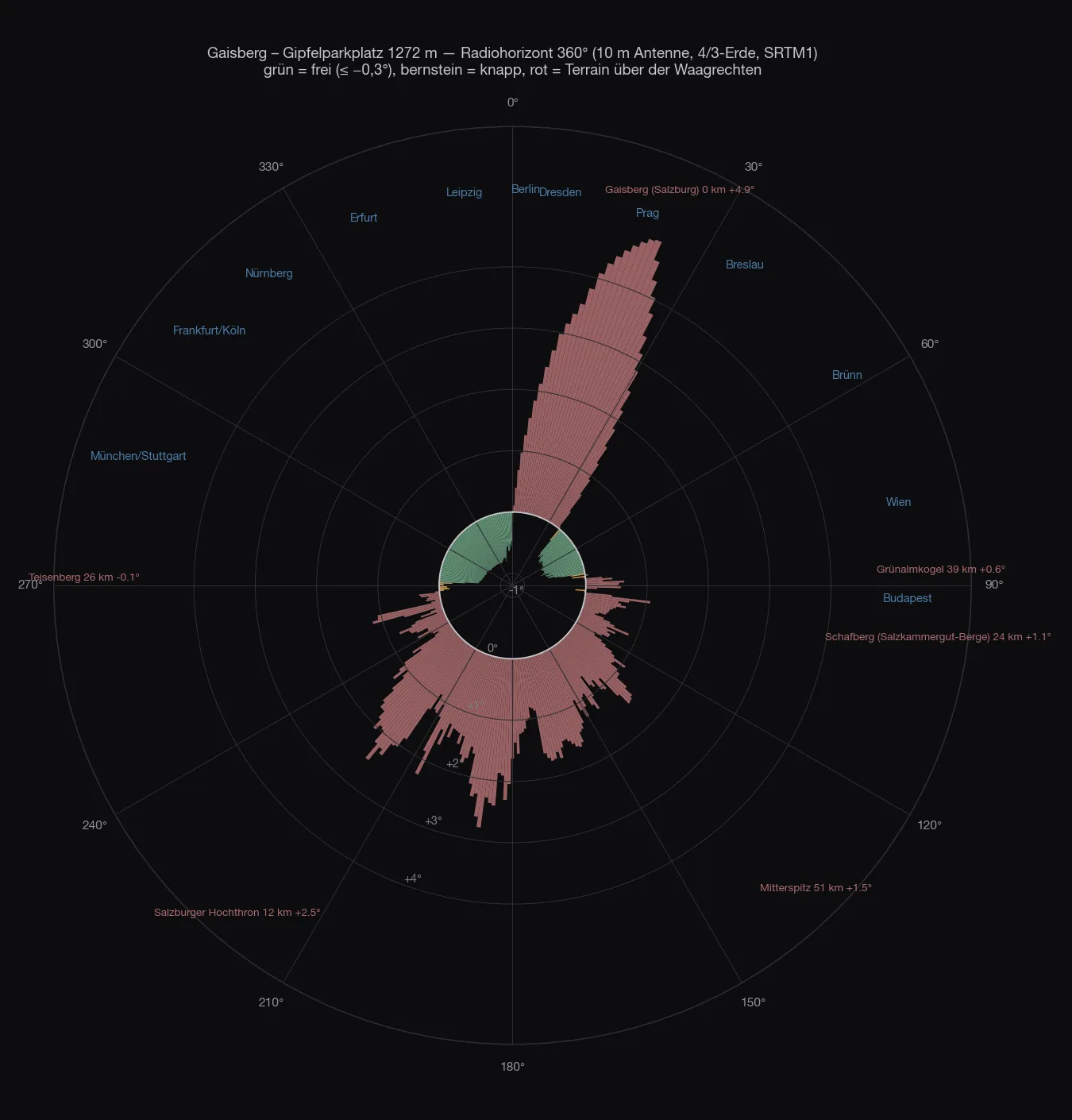
From 273° to 359° everything is clear, −0.4 to −0.8 degrees. Munich, Stuttgart, Frankfurt, Cologne, Hanover, Hamburg — nothing in the way until the earth curves away. That is the best German sector any site with a road has to offer around here.
Then comes the dome. The summit with the ORF transmitter tower stands two hundred metres north of the car park and closes 2° to 43° at ten metres of antenna height, by up to +5.2 degrees. Behind it lie Berlin (+1.4°), Dresden (+3.4°), Prague (+2.8°), Wrocław (+1.4°), Passau (+2.5°) and Nuremberg (+3.6°) — everything north-east of the Danube is looked at up a slope. A second, smaller hole is made by a house with trees, 15 to 18 metres high, ninety metres to the north-west: 313° to 322°, +4.5 degrees.
Height helps, but only slowly. What stays clear at the car park:
| Antenna height | clear of 2,262 | of those Germany | DARC list |
|---|---|---|---|
| 8 m | 711 | 347 | 634 of 1,327 |
| 10 m | 803 | 414 | 758 |
| 11.8 m | 942 | 508 | 941 |
| 13.5 m | 1,016 | 568 | 1,050 |
Thirteen and a half metres of mast, only to see over a dome two hundred metres away — and Nuremberg is still +1.4 degrees above it.
The site
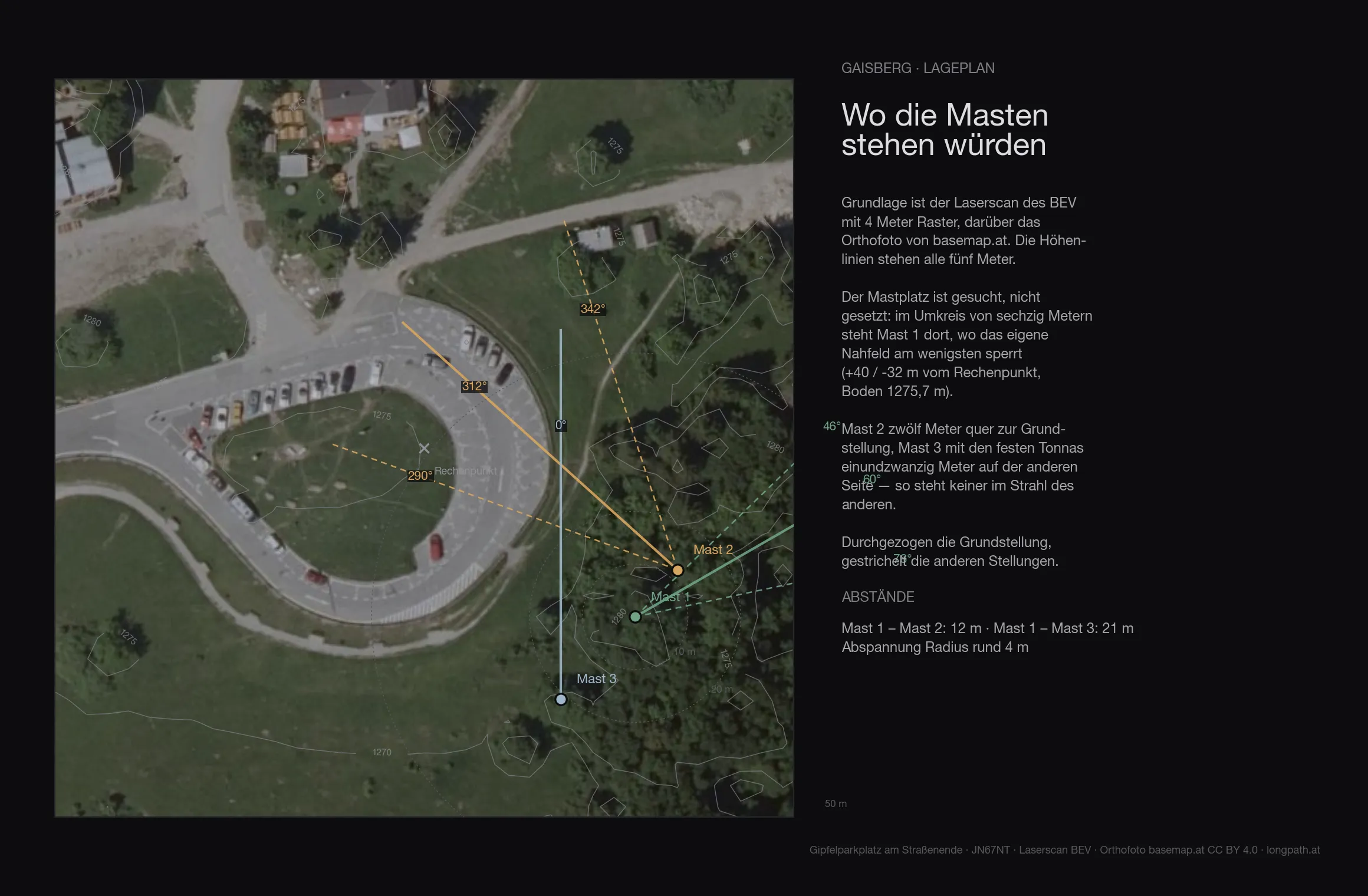
The terrain of the first 136 metres around the site comes from the Austrian lidar survey on a four-metre grid — trees, buildings and knolls included. The ground at the mast is at 1275.7 metres.
| Antenna height | Directions blocked by the near field |
|---|---|
| 6 m | 73° |
| 8 m | 31° |
| 10 m | 13° |
| 12 m | 6° |
| 15 m | 2° |
Even with ten metres of mast the near field still blocks 13 degrees — on top of whatever the far horizon closes off anyway.
A hundred and forty metres further
Walk north-west from the car park, to the area at the repeater (47.80393 N / 13.10985 E, 1,277 m), and the picture turns around: the dome is then behind you, not in the way. 1,200 stations are clear at ten metres, 1,253 at 11.8, 1,295 at 13.5 — and of the DARC list 1,325 of 1,327 are clear, at any height. Closed instead is the sector 44° to 68°, so Poland and Czechia, which from there lie behind the dome.
Better still is the summit meadow north of the transmitter (ground 1,284 m): 1,513 clear stations, regardless of mast height — apart from the south, where the Alps are, everything is open. The price is two hundred and fifty metres of carrying and sixty metres of distance to the 100 kW tower.
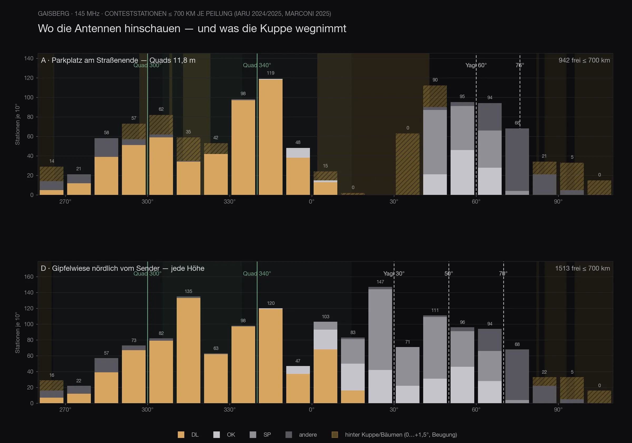
For the planned setup — one Yagi stack and one quad stack, each on three rotor positions, power split — that means, at the car park: 827 reachable stations, 506 of them in Germany, with the Yagi stack on 312°, 342° and 60° and the quad stack on 88°, 282° and 284°. Counting only the German stations and only the two quads, 300° and 340° together bring 852 of 1,327 — from the summit meadow the same directions would give 1,319.
The map
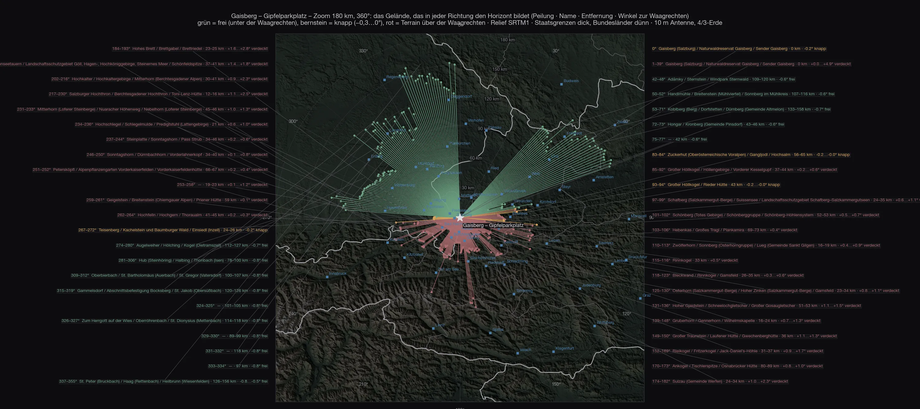
Every stroke is one degree. To the west and north-west they run out into the Bavarian lowlands, because that is where the terrain forming the horizon begins; to the east and south they stop at the site’s own knoll and at the rim of the Alps.
Out to 700 kilometres
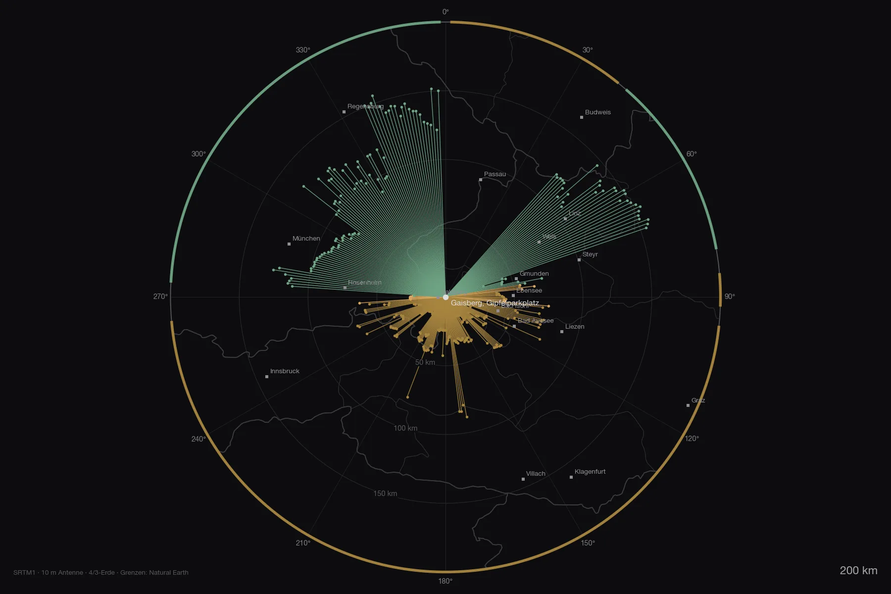
Both maps as PDF: zoom 180 km and overview 800 km. To the south the Watzmann (31 km, 208°, +2.6°), the Großglockner (87 km, +1.4°) and the Hochalmspitze rise above the horizontal — to the north and west nothing does, out to eight hundred kilometres.
The stations
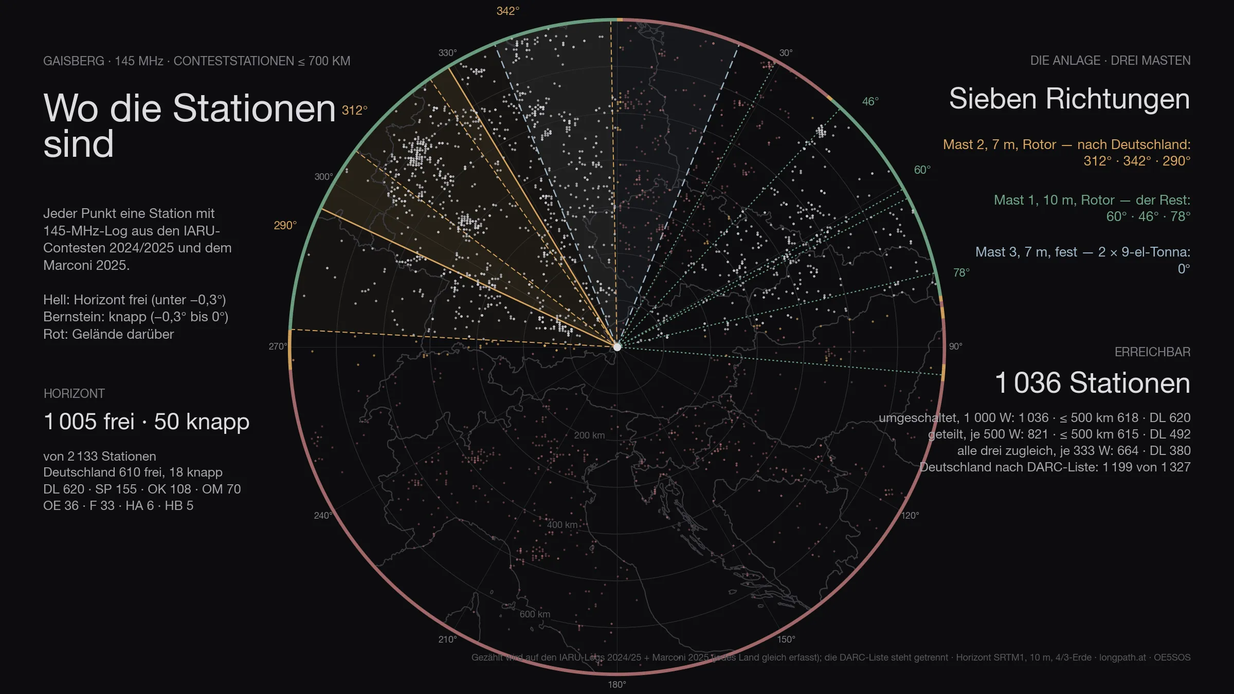
Of the 2 133 stations that appear in the logs within 700 kilometres, 1 055 are above the horizon — Germany 628 of 703. That is the ceiling: no antenna, however large, gets past it.
The figure has two halves. Genuinely clear — horizon more than three tenths of a degree below the horizontal — are 1 005 stations, 610 of them in Germany. The other 50 are marginal: between −0.3° and zero, in the grazing shadow of an edge. Something works there, but at a loss of three to eight decibels depending on the day. Both numbers are given, because only both together describe the site. Of the 127 degrees that are clear, 15 marginal degrees come on top.
The antennas
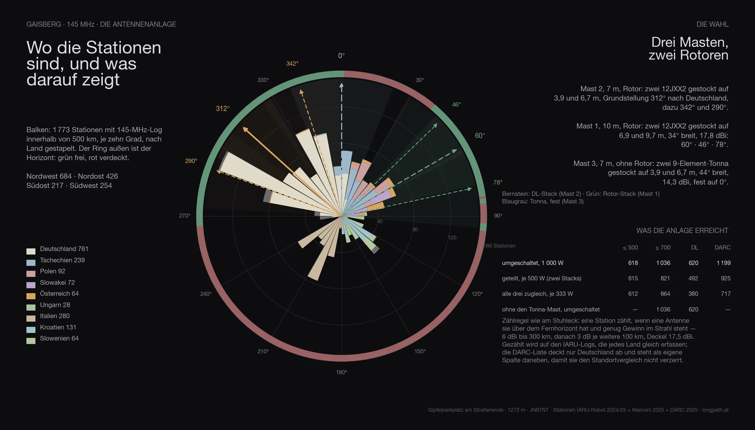
The same array is computed everywhere as the one on the Stuhleck, with three masts:
- Mast 2, 7 metres, rotator: two 12JXX2 stacked at 3.9 and 6.7 m — the stack that looks at Germany.
- Mast 1, 10 metres, rotator: two 12JXX2 stacked at 6.9 and 9.7 m, 34° wide, 17.8 dBi.
- Mast 3, 7 metres, no rotator: two stacked 9-element Tonnas at 3.9 and 6.7 m, 44° wide, 14.3 dBi — fixed on one heading.
The headings are not guessed but searched: for Gaisberg they come out at 312° / 342° / 290° for the DL stack, 60° / 46° / 78° for the rotator stack and 0° for the fixed Tonnas.
Feeding goes through a switch. With the full 1 000 watts on whichever system is being worked, the array reaches 1 055 stations across the contest (Germany 628, by the DARC list 1 199). Split across the two rotator stacks, 500 watts each, it is 862; with only three fixed headings per rotator 1 036; spread over all three systems at once only 664 — three directions cost more power than they gain in coverage. The Tonna mast alone adds 0 stations that would otherwise be missing.
In three dimensions
The same view for every site: the terrain comes from the Austrian lidar survey, the orthophoto lies on top, and the two masts stand on it at their computed heights. The labels around the rim are cities — bright means above the horizon, grey means behind it.
The comparison
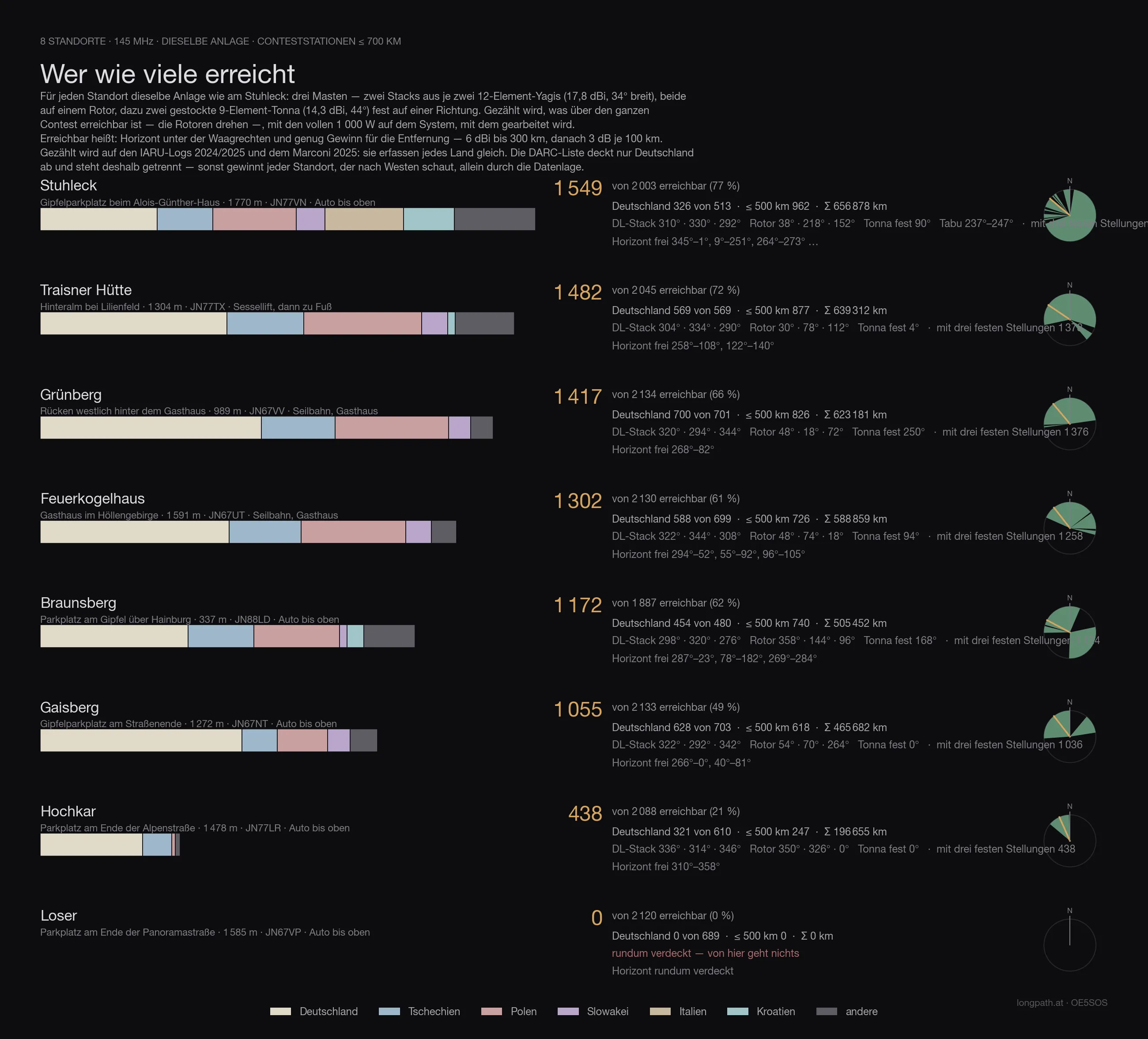
Every site in this series with the same array, the same counting rule and the same logs — only then are the numbers comparable. Reached means: horizon below the horizontal and enough gain for the distance (6 dBi to 300 km, then 3 dB per further 100 km), with 1 000 watts on whichever system is being worked. Both large antennas sit on rotators — so the count is what is reachable across the whole contest, not what one fixed heading covers.
The count runs on the IARU logs 2024/2025 and the Marconi 2025: they record every country alike. The DARC list covers Germany only — it sits in its own column, otherwise every site that looks west wins on the data alone.
| Site | reached | Germany | DARC list | ≤ 500 km | Access |
|---|---|---|---|---|---|
| Stuhleck · 1 770 m | 1 549 | 326 | 569 | 962 | drive to the top |
| Traisner Hütte · 1 304 m | 1 482 | 569 | 988 | 877 | chairlift, then on foot |
| Grünberg · 989 m | 1 417 | 700 | 1 271 | 826 | cable car, inn |
| Feuerkogelhaus · 1 591 m | 1 302 | 588 | 1 056 | 726 | cable car, inn |
| Braunsberg · 337 m | 1 172 | 454 | 814 | 740 | drive to the top |
| Gaisberg · 1 272 m | 1 055 | 628 | 1 199 | 618 | drive to the top |
| Hochkar · 1 478 m | 438 | 321 | 559 | 247 | drive to the top |
| Loser · 1 585 m | 0 | 0 | 0 | 0 | drive to the top |
Gaisberg therefore comes 6 of 8.
Anyone who knows the earlier articles in this series will find different numbers there: those were computed with the first line-up — one Yagi stack and one quad stack with a 69° beamwidth. Since the choice fell on two narrow 12JXX2 stacks, the order shifts: more gain and less width favours the sites whose stations bunch in one direction, and costs the ones that stand open all round. The fixed Tonnas on mast 3 win part of that width back.
The data
| Site | Gaisberg — Gipfelparkplatz am Straßenende |
| Coordinates | 47,80336 N / 13,11151 O · 1 272 m · JN67NT |
| Access | road all the way up |
| Horizon clear | 266°–0°, 40°–81° |
| Degrees clear / marginal / blocked | 127° / 15° / 218° |
| Stations ≤ 700 km | 1 005 clear, 50 marginal, of 2 133 |
| Germany (IARU) | 610 clear, 18 marginal, of 703 |
| Germany (DARC list) | 1 217 below the horizontal of 1 327 |
| Array | three masts · mast 1 10 m (2 × 12JXX2 at 6.9/9.7 m, rotator) · mast 2 7 m (2 × 12JXX2 at 3.9/6.7 m, rotator) · mast 3 7 m (2 × 9-el Tonna at 3.9/6.7 m, fixed) |
| Headings | DL-Stack 312° / 342° / 290° · Rotor-Stack 60° / 46° / 78° · Tonna fest 0° |
| switched · 1 000 W | 1 055 · ≤ 500 km 618 · DL 628 · with three fixed headings per rotator 1 036 |
| split · 500 W each | 862 · ≤ 500 km 618 · DL 526 |
| all three at once · 333 W each | 664 · ≤ 500 km 612 · DL 380 |
| without the Tonna mast | 1 036 instead of 1 036 |
| Σ kilometres | 465 682 km |
| strict count | only directions below −0.3°: 788 · ≤ 500 km 578 · DL 483 |
What it means
The Gaisberg is not an empty mountain. A transmitter park has stood on the summit for decades, and you do not simply drive into the middle of it with a contest station:
- The 2 m repeater OE2XZR on 145.6875 MHz stands 139 metres from the car park — and at 297°, right in the direction you want to beam towards Germany. Plus the APRS digipeater on 144.800 MHz. Both are in the very band you intend to work with high power for two days. It cuts both ways: what an amplifier 139 metres away puts into a repeater input makes that repeater useless for the duration of the contest.
- Two hundred and ten metres further stands the ORF transmitter: four FM programmes at 100 kW each plus DAB+. A receiver meant to listen on 145 MHz sits there in a field against which any preselection is a compromise.
- The place is also taken: the IARU logs of 2024 and 2025 show OE2M with JN67NT and 1,270 metres — the Salzburg radio club operates from there. Two stations on 145 MHz on the same plateau are not a good idea.
- And the summit meadow, which would be the best one on paper, is a paraglider launch site.
That is the real answer to the question “Gaisberg?”: not the geography, but the neighbourhood.
Caveat
A calculation, not a measurement. The SRTM grid is thirty metres, the lidar four; the far field knows neither trees nor buildings, only terrain. Propagation assumes a standard atmosphere — a tropo evening computes differently, and in the marginal directions it decides more than any tenth of a degree in this table. The station count is a model calculation with antenna patterns from manufacturer data, not a prediction of contacts.
The rest gets measured — up there, with an antenna.
73 · OE5SOS