What the Braunsberg sees
A paved car park at 343 metres, right at the summit, road all the way up, eleven kilometres to Bratislava: a site can hardly be better placed. The horizon says otherwise — the south-east lies wide open, and towards Germany the Vienna Woods sit almost exactly on the line of sight.
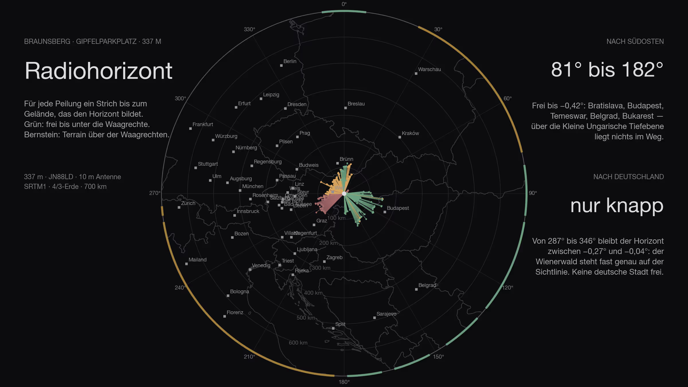
The site is every portable station’s dream: a paved surface sixty by thirty metres, road all the way up, public, no barrier in front of it, and the summit forty metres to the side. Hainburg an der Donau below, Bratislava eleven kilometres east, the March and the Slovak border in sight.
The question is not the site. The question is what rises above the horizon from there — and whether Germany is part of it, where most of the other stations sit.
How
The method is the same as for the Feuerkogel, Stuhleck and the other sites in this series: SRTM terrain model, one ray per degree out to 500 kilometres, ten metres of antenna height, earth curvature with the 4/3 radius, obstacle names from Wikipedia. This time with the Austrian lidar survey for the first 140 metres around the site — trees, knoll, hut — and the contest logs laid over it.
Three classes: clear means more than three tenths of a degree below the horizontal, marginal between −0.3° and zero, blocked means terrain above the horizontal.
All the way round
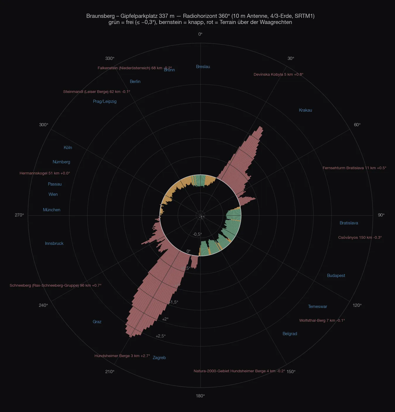
Of 360 degrees, 107 are clear, 113 marginal and 140 blocked. That is the worst ratio in the whole series — and still the site is not bad, because the clear degrees point where the activity is.
| Direction | What sets the horizon | Distance | Angle |
|---|---|---|---|
| 353–7° | clear — South Moravia: Boleradice, Hustopeče, Ždánický les | 85–117 km | −0.30…−0.35° |
| 8–23° | marginal — Little Carpathians, Brdo, Radimov | 5–116 km | −0.29…0.00° |
| 24–77° | Devínska Kobyla and the Little Carpathians | 5–20 km | +0.02…+1.84° |
| 81–97° | clear — across Bratislava into Slovakia | 11–147 km | −0.34…−0.42° |
| 99–129° | clear — Danube plain, Csóványos, Bajót | 6–151 km | −0.31…−0.42° |
| 133–179° | clear — Little Hungarian Plain, Bakony | 3–133 km | −0.30…−0.41° |
| 183–261° | Hundsheimer Berg (480 m, 3 km), the Alps behind it | 2–129 km | +0.00…+2.76° |
| 263–266° | Schöpfl and the Vienna Woods ridge | 54–78 km | +0.05…+0.14° |
| 269–284° | marginal — Vienna Woods: Troppberg, Dahaberg | 52–71 km | −0.01…−0.12° |
| 287–346° | marginal — Kahlenberg, Leiser Berge, Weinviertel | 34–99 km | −0.04…−0.27° |
Two hills close off half the circle. The Hundsheimer Berg, 480 metres high and three kilometres south-west, stands in the way at up to +2.76° — it takes everything from south through south-west to west: Graz, Slovenia, Croatia, Italy and the whole of the Alps. The Devínska Kobyla on the Slovak side, 514 metres, five kilometres north-east, closes the north-east at +1.84°: Kraków, Warsaw, eastern Poland.
And then there is the west. From 269° to 346° — the entire sector in which Germany lies — the horizon stays between −0.27° and −0.01°. That is neither clear nor blocked: it is the Vienna Woods, 34 to 99 kilometres out, sitting almost exactly on the line of sight.
The site
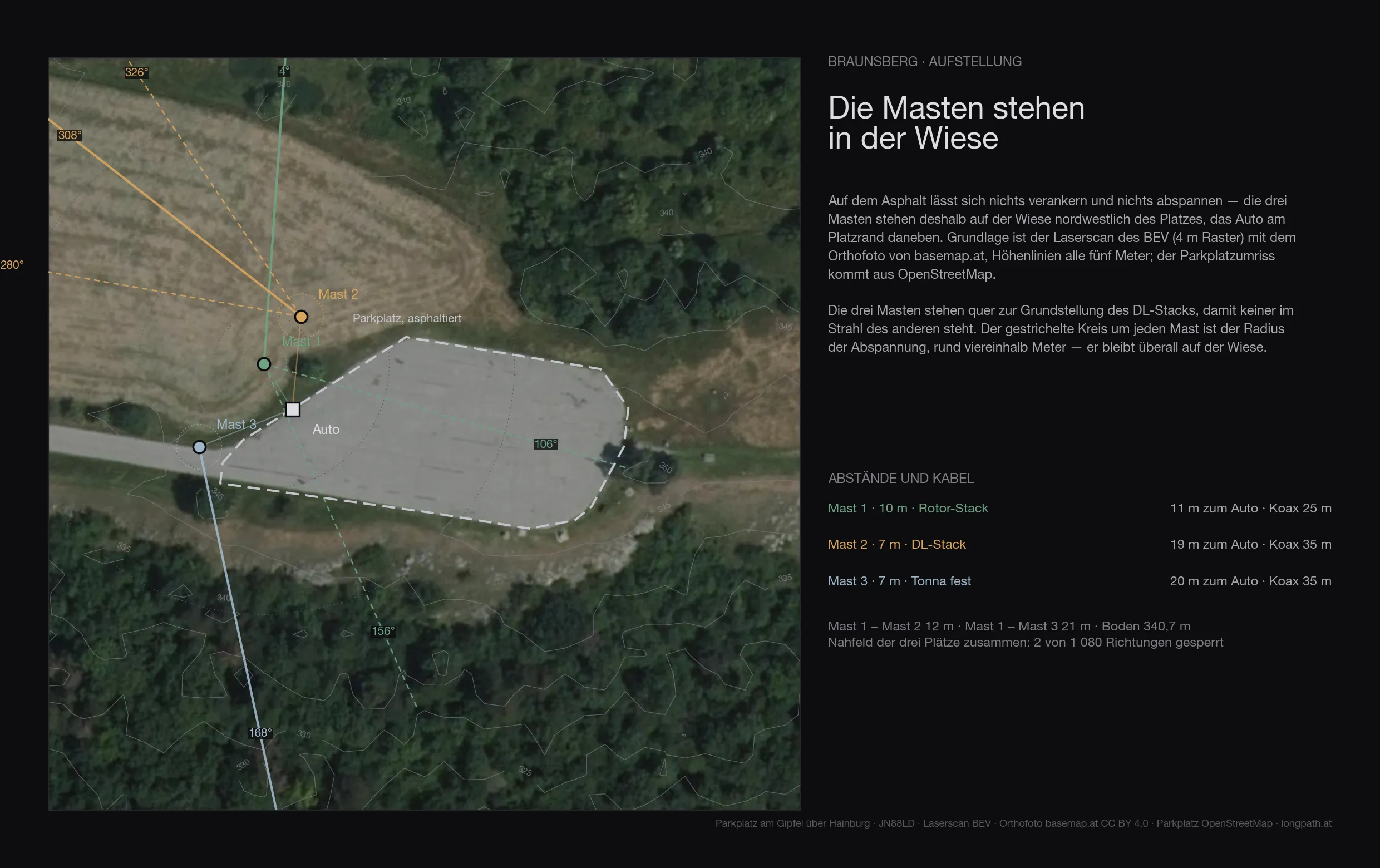
The lidar has nothing but good to say about the site itself. The asphalt lies at 343 metres (SRTM works with 337, the scan measures more precisely), it is level, and within the first 140 metres almost nothing stands around it:
| Antenna height | Directions blocked by the near field |
|---|---|
| 6 m | 6° |
| 8 m | 1° |
| 10 m | none |
| 12 m and above | none |
But nothing gets set up on the asphalt — pegs and guy ropes need grass. The ground provides it: an open meadow adjoins the car park to the north-west, smooth in the lidar and free of trees in the orthophoto. The three masts stand there across the base heading of the DL stack, so that none is in another’s beam, with the car at the edge of the parking area beside them:
| position from the centre of the site | to the car | coax | |
|---|---|---|---|
| mast 1 · 10 m · rotator stack | 32 m west, 14 m north | 11 m | 25 m |
| mast 2 · 7 m · DL stack | 25 m west, 23 m north | 19 m | 35 m |
| mast 3 · 7 m · Tonnas, fixed | 45 m west, 3 m south | 20 m | 35 m |
The ground at the mast positions is 340.7 metres, a good two metres below the asphalt. The guying radius — about four and a half metres — stays on grass at all three. In this arrangement the near field costs two of 1 080 directions in total; a spot further north-west would be completely clear, but would put twenty-three more metres of cable between car and mast.
Two things that are not in the terrain model: the Braunsberg is a Celtic oppidum — a registered archaeological site lies a hundred and seventy metres west of the car park, and there are several memorials at the summit. Anyone driving pegs into this ground clears that first. And the Hundsheimer Berge are a Natura 2000 area; the car park itself lies at its edge.
The map
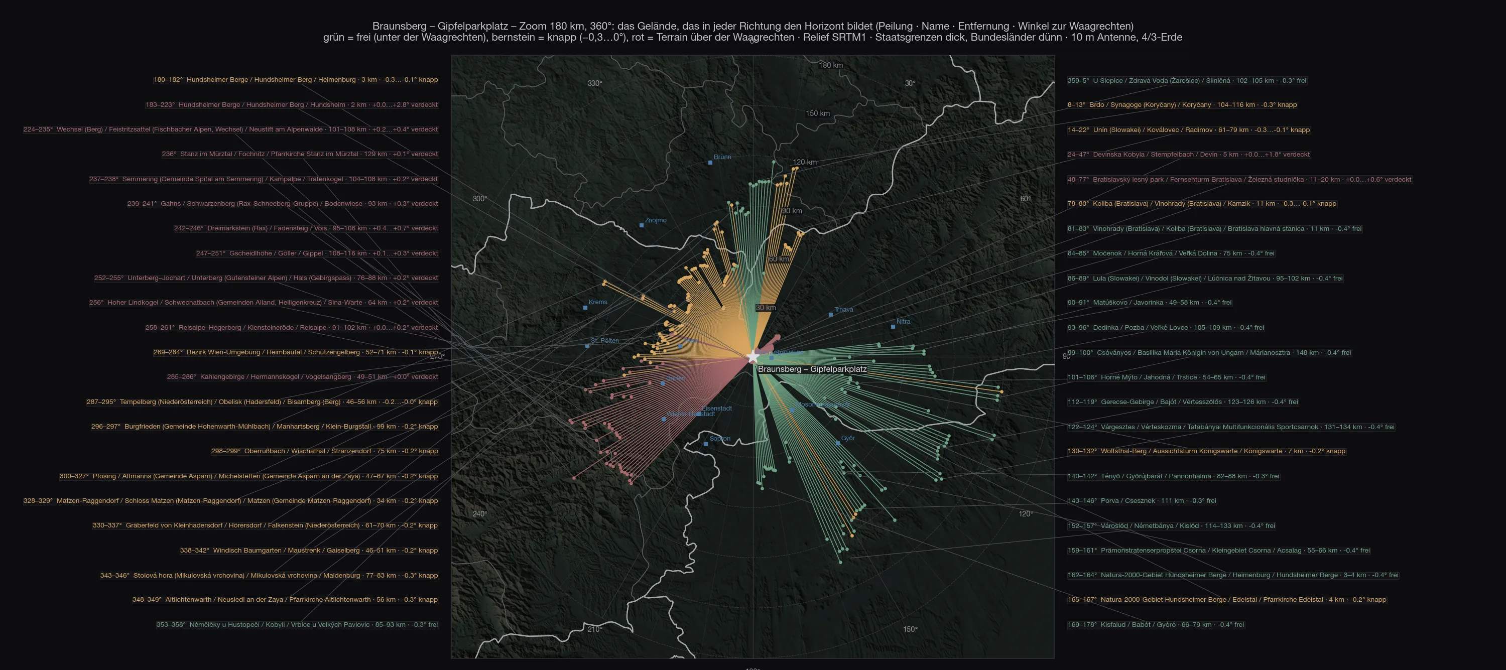
The difference from every mountain site in this series is immediately visible: the strokes to the south-east run 130 to 150 kilometres, into the Bakony and to the Danube at Budapest. To the south-west they stop after two kilometres — at the neighbouring hill.
Out to 700 kilometres
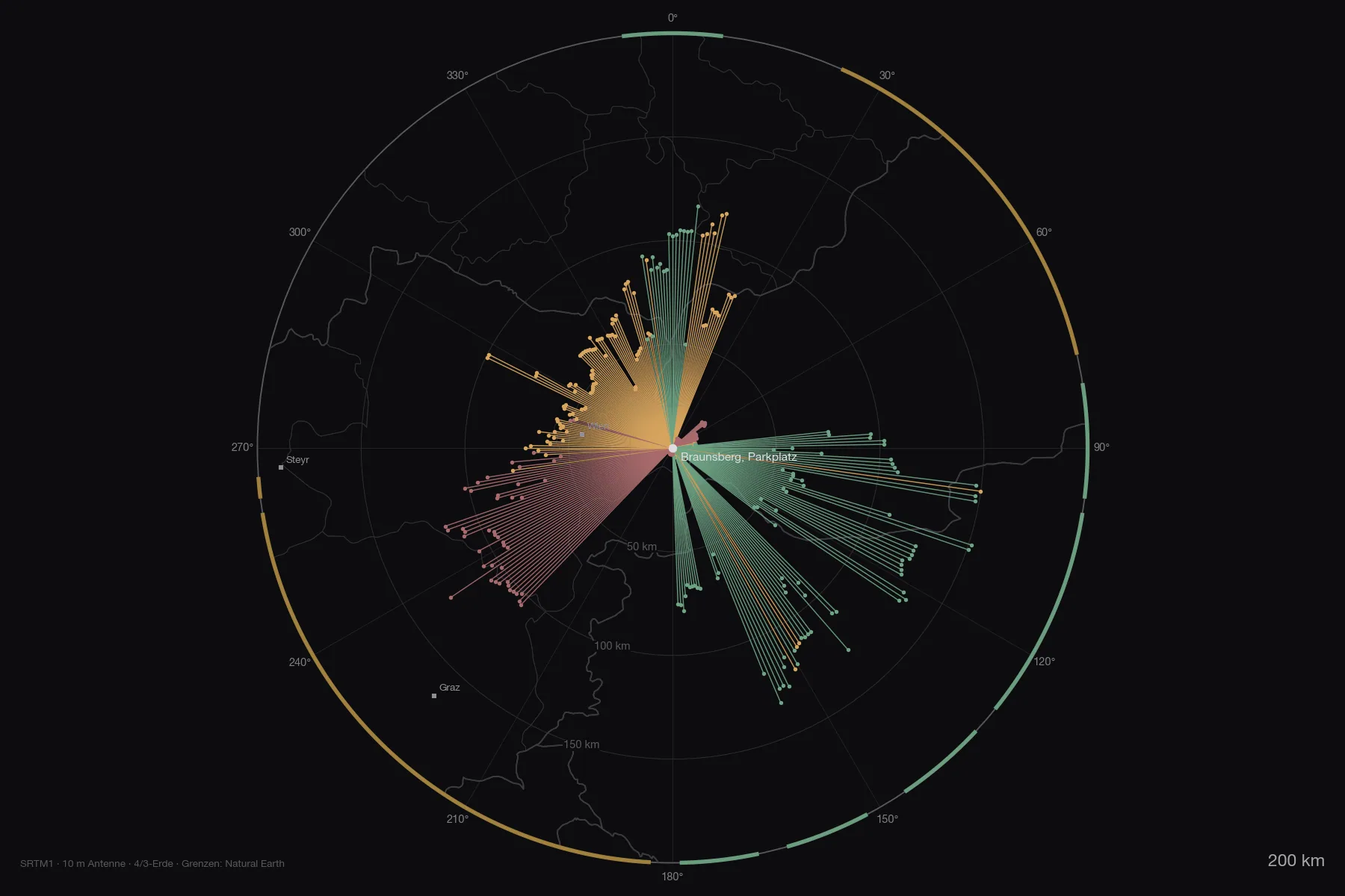
The overview out to 800 kilometres lists the ranges with their angles. Only close neighbours rise above the horizontal and, further out, the rim of the Alps to the west: Schneeberg +0.72° at 95 kilometres, Hochschwab +0.25° at 148, Ötscher +0.21° at 134. Everything beyond — Bavarian Forest, Ore Mountains, Harz — lies far below the horizon; it just does not get there, because the Vienna Woods stand in front.
Both maps as PDF: zoom 180 km with all the mountain names and overview 800 km with the numbered list.
The stations
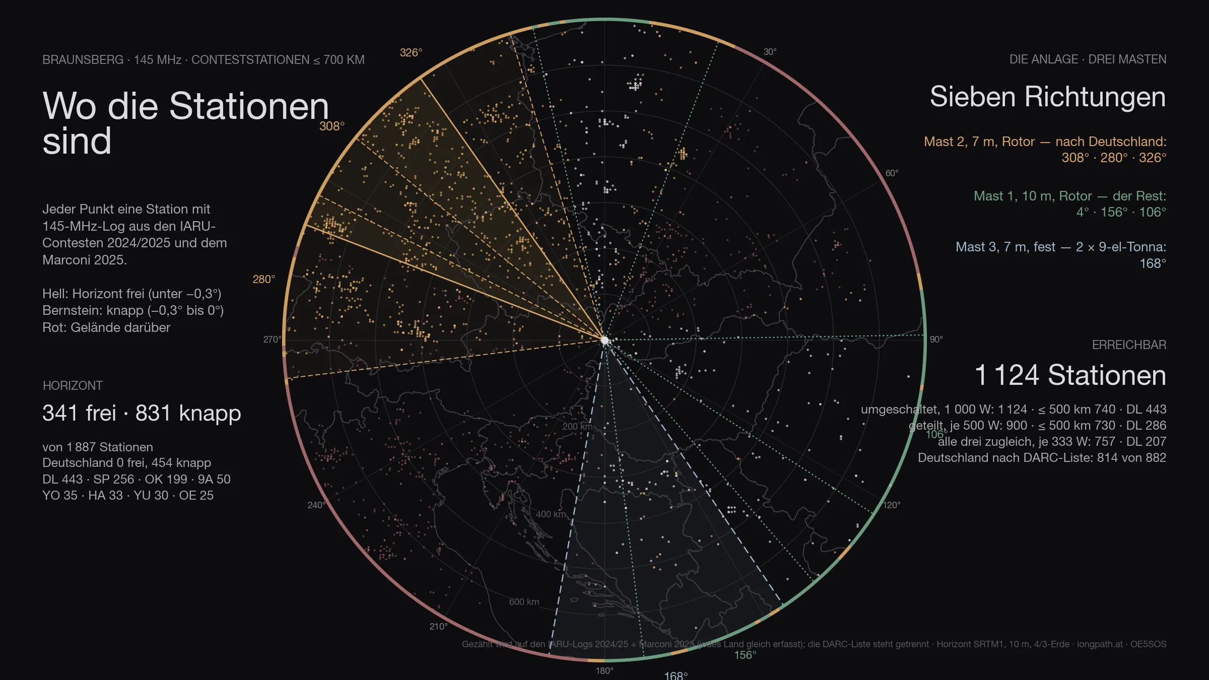
Of the 1 887 stations that appear in the logs within 700 kilometres, 1 172 are above the horizon — Germany 454 of 480. That is the ceiling: no antenna, however large, gets past it.
The figure has two halves. Genuinely clear — horizon more than three tenths of a degree below the horizontal — are 341 stations, 0 of them in Germany. The other 831 are marginal: between −0.3° and zero, in the grazing shadow of an edge. Something works there, but at a loss of three to eight decibels depending on the day. Both numbers are given, because only both together describe the site. Of the 107 degrees that are clear, 113 marginal degrees come on top.
The antennas
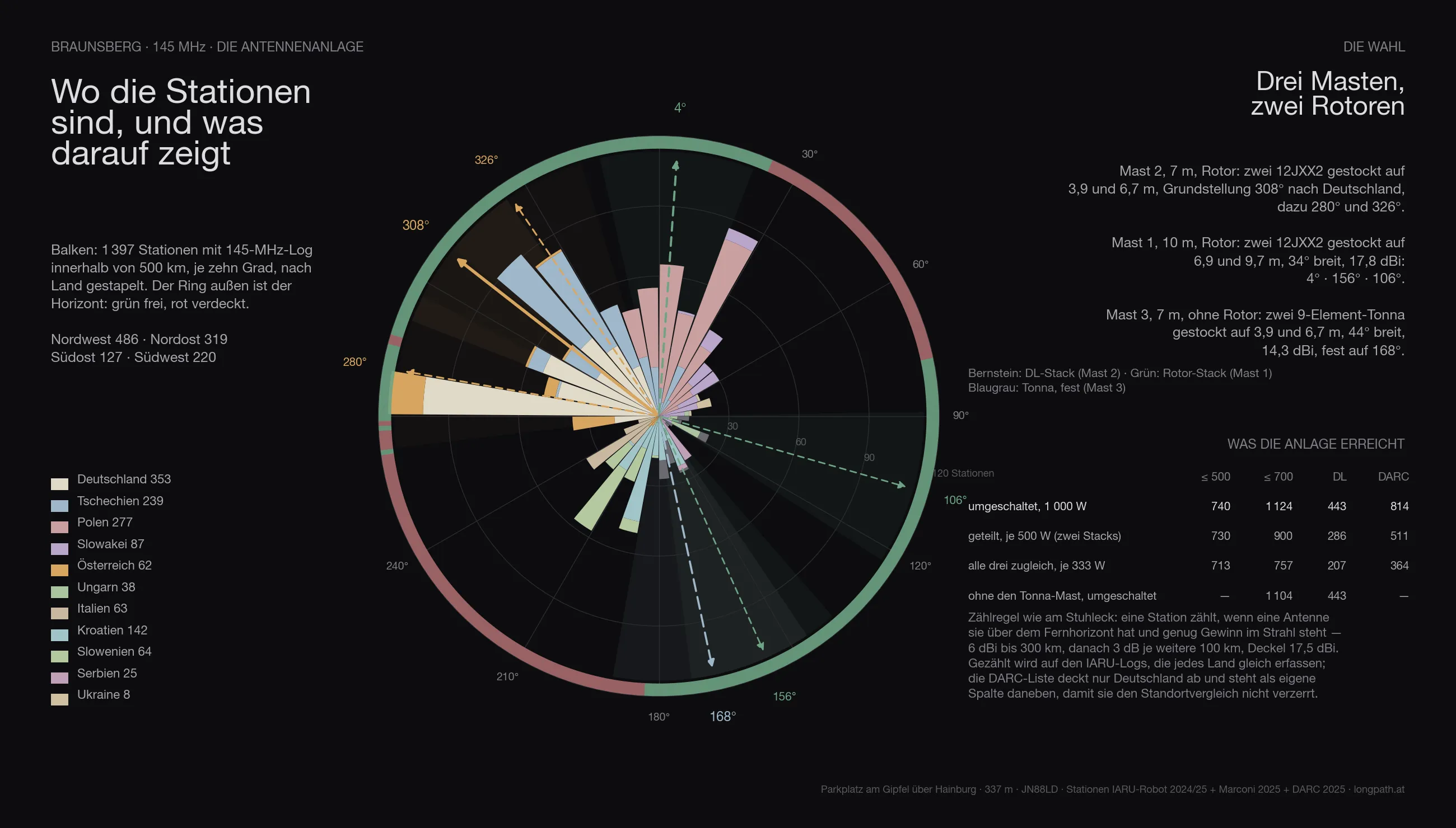
The same array is computed everywhere as the one on the Stuhleck, with three masts:
- Mast 2, 7 metres, rotator: two 12JXX2 stacked at 3.9 and 6.7 m — the stack that looks at Germany.
- Mast 1, 10 metres, rotator: two 12JXX2 stacked at 6.9 and 9.7 m, 34° wide, 17.8 dBi.
- Mast 3, 7 metres, no rotator: two stacked 9-element Tonnas at 3.9 and 6.7 m, 44° wide, 14.3 dBi — fixed on one heading.
The headings are not guessed but searched: for Braunsberg they come out at 308° / 280° / 326° for the DL stack, 4° / 156° / 106° for the rotator stack and 168° for the fixed Tonnas.
Feeding goes through a switch. With the full 1 000 watts on whichever system is being worked, the array reaches 1 172 stations across the contest (Germany 454, by the DARC list 814). Split across the two rotator stacks, 500 watts each, it is 947; with only three fixed headings per rotator 1 124; spread over all three systems at once only 757 — three directions cost more power than they gain in coverage. The Tonna mast alone adds 20 stations that would otherwise be missing.
In three dimensions
The same view for every site: the terrain comes from the Austrian lidar survey, the orthophoto lies on top, and the two masts stand on it at their computed heights. The labels around the rim are cities — bright means above the horizon, grey means behind it.
The comparison
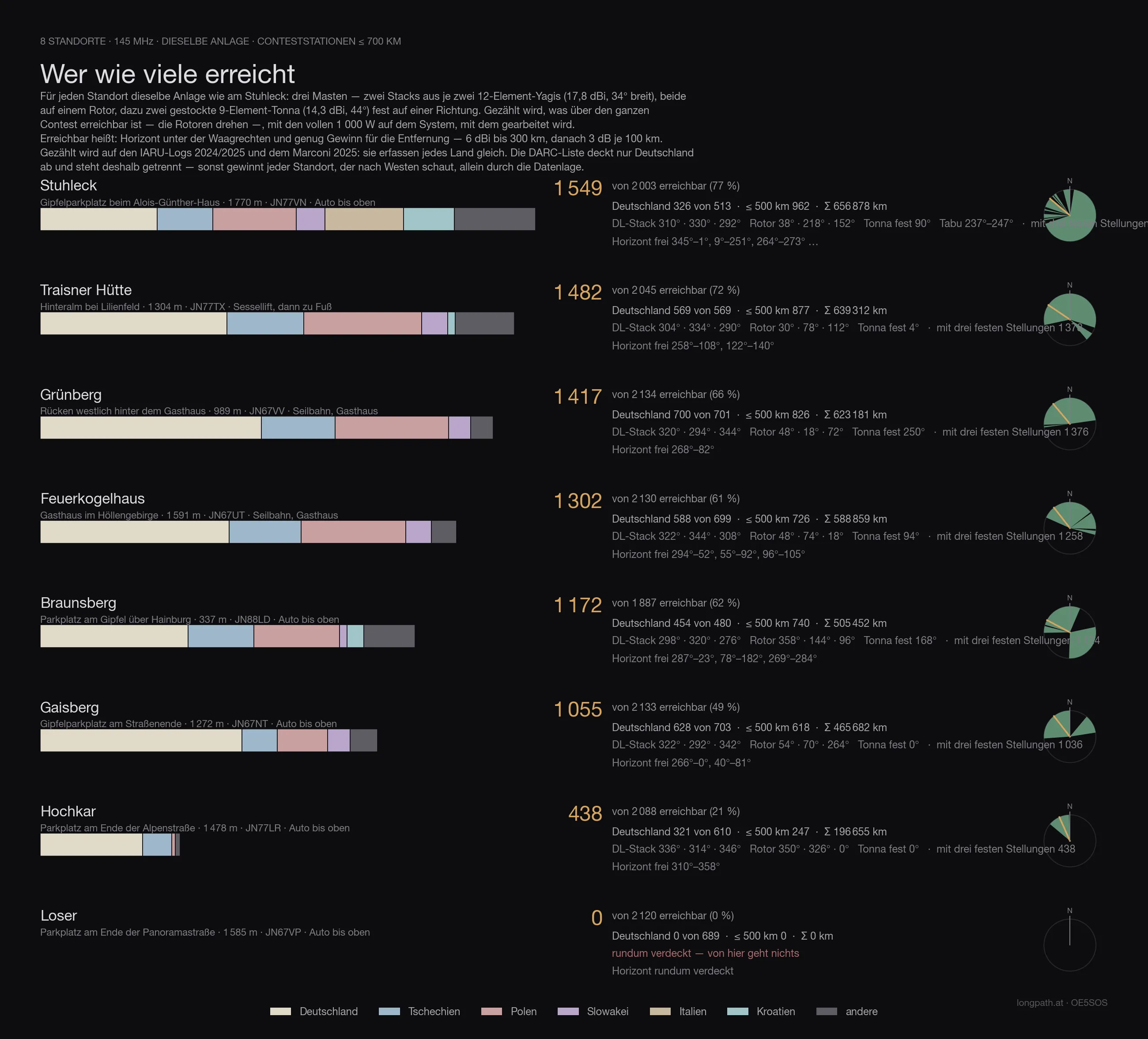
Every site in this series with the same array, the same counting rule and the same logs — only then are the numbers comparable. Reached means: horizon below the horizontal and enough gain for the distance (6 dBi to 300 km, then 3 dB per further 100 km), with 1 000 watts on whichever system is being worked. Both large antennas sit on rotators — so the count is what is reachable across the whole contest, not what one fixed heading covers.
The count runs on the IARU logs 2024/2025 and the Marconi 2025: they record every country alike. The DARC list covers Germany only — it sits in its own column, otherwise every site that looks west wins on the data alone.
| Site | reached | Germany | DARC list | ≤ 500 km | Access |
|---|---|---|---|---|---|
| Stuhleck · 1 770 m | 1 549 | 326 | 569 | 962 | drive to the top |
| Traisner Hütte · 1 304 m | 1 482 | 569 | 988 | 877 | chairlift, then on foot |
| Grünberg · 989 m | 1 417 | 700 | 1 271 | 826 | cable car, inn |
| Feuerkogelhaus · 1 591 m | 1 302 | 588 | 1 056 | 726 | cable car, inn |
| Braunsberg · 337 m | 1 172 | 454 | 814 | 740 | drive to the top |
| Gaisberg · 1 272 m | 1 055 | 628 | 1 199 | 618 | drive to the top |
| Hochkar · 1 478 m | 438 | 321 | 559 | 247 | drive to the top |
| Loser · 1 585 m | 0 | 0 | 0 | 0 | drive to the top |
Braunsberg therefore comes 5 of 8.
Anyone who knows the earlier articles in this series will find different numbers there: those were computed with the first line-up — one Yagi stack and one quad stack with a 69° beamwidth. Since the choice fell on two narrow 12JXX2 stacks, the order shifts: more gain and less width favours the sites whose stations bunch in one direction, and costs the ones that stand open all round. The fixed Tonnas on mast 3 win part of that width back.
The data
| Site | Braunsberg — Parkplatz am Gipfel über Hainburg |
| Coordinates | 48,15348 N / 16,95733 O · 337 m · JN88LD |
| Access | road all the way up |
| Horizon clear | 287°–23°, 78°–182°, 269°–284° |
| Degrees clear / marginal / blocked | 107° / 113° / 140° |
| Stations ≤ 700 km | 341 clear, 831 marginal, of 1 887 |
| Germany (IARU) | 0 clear, 454 marginal, of 480 |
| Germany (DARC list) | 842 below the horizontal of 882 |
| Array | three masts · mast 1 10 m (2 × 12JXX2 at 6.9/9.7 m, rotator) · mast 2 7 m (2 × 12JXX2 at 3.9/6.7 m, rotator) · mast 3 7 m (2 × 9-el Tonna at 3.9/6.7 m, fixed) |
| Headings | DL-Stack 308° / 280° / 326° · Rotor-Stack 4° / 156° / 106° · Tonna fest 168° |
| switched · 1 000 W | 1 172 · ≤ 500 km 740 · DL 454 · with three fixed headings per rotator 1 124 |
| split · 500 W each | 947 · ≤ 500 km 740 · DL 300 |
| all three at once · 333 W each | 757 · ≤ 500 km 713 · DL 207 |
| without the Tonna mast | 1 104 instead of 1 124 |
| Σ kilometres | 505 452 km |
| strict count | only directions below −0.3°: 297 · ≤ 500 km 240 · DL 0 |
What it means
For the east and south-east the Braunsberg is a very good site, and with a convenience no mountain site offers: drive up, set up, done. Bratislava −0.40°, Budapest −0.33°, Timișoara −0.42°, Belgrade −0.30°, Bucharest −0.32°, Brno −0.30°, Wrocław −0.31° — all clear, most of it over flat land. There is enough activity in the Little Hungarian Plain and along the Danube during a contest, and the distances count double.
Towards Germany it is the weakest site in the series, and not by a little. Not one of the thirty German cities stands genuinely clear: Munich −0.05°, Passau −0.02°, Stuttgart −0.07°, Nuremberg −0.12°, Frankfurt −0.09°, Leipzig −0.13°, Dresden −0.20°, Hamburg −0.21°, Berlin −0.24°, Cologne −0.23°. All of them between zero and a quarter of a degree below — the Vienna Woods clip every one of those paths. That does not mean nothing works: an edge at fifty kilometres costs three to eight decibels depending on the day, and with 1 000 watts on one stack 454 German stations are in the calculation (814 by the DARC list) that would be reachable elsewhere. But they never arrive cleanly, and a tropo evening helps less here than on a mountain that stands free.
Mast height changes nothing about this. Five metres more antenna shifts the angle to an edge fifty kilometres away by six thousandths of a degree. What is missing here is not metres but kilometres of distance from the Vienna Woods — or a position behind them.
So anyone running a contest from the Braunsberg turns east and south-east and takes Germany for what it is there: a sector you work when conditions play along, not the one you point the fixed antenna at. For Germany, Grünberg, Gaisberg and Feuerkogel remain the addresses.
Caveat
A calculation, not a measurement. The SRTM grid is thirty metres, the lidar four; the far field knows neither trees nor buildings, only terrain. Propagation assumes a standard atmosphere — a tropo evening computes differently, and in the marginal directions it decides more than any tenth of a degree in this table. The station count is a model calculation with antenna patterns from manufacturer data, not a prediction of contacts.
What the calculation does say for certain: where this site stands open, and that the west has an edge.
The rest gets measured — up there, with an antenna.
73 · OE5SOS