What the Loser sees — and what it doesn't
The car park at the end of the Loser Panoramastraße lies at 1,585 metres, and still it is closed all round. I calculated the whole road, both car parks, both top stations and the summit, plus the contest logs: who could be reached from there. Only one of them looks towards Germany, and you have to walk to it.
The third site after the Feuerkogel and the Grünberg, and the first with a road: the Loser Panoramastraße climbs from Altaussee to 1,585 metres, at the top a car park with a turning area, the mountain restaurant, the top station of the Panoramabahn gondola. Below it, at the Loserhütte, a second car park at 1,506 metres. Drive up, set up, done — that was the idea.
But the road is not the only way up the Loser. The Panoramabahn gondola runs from Altaussee to 1,604 metres, and above it the Loserfenster chairlift ends at 1,757 metres — a top station usually stands a little higher and clearer than the car park. So everything was calculated: car parks, road, both top stations and the summit.
How
The method is the same as for the five sites before: SRTM terrain model, one ray per degree, ten-metre antenna, 4/3 earth, 500 kilometres out, the names of the obstacles from Wikipedia. New is the second step from the last post: the 3,215 contest logs of the IARU contests 2024 and 2025 recalculated for this site — for every station bearing, distance and the question whether the horizon in its direction is clear. This time not just for one point but for the whole road, point by point, plus both top stations and the summit.
All the way round
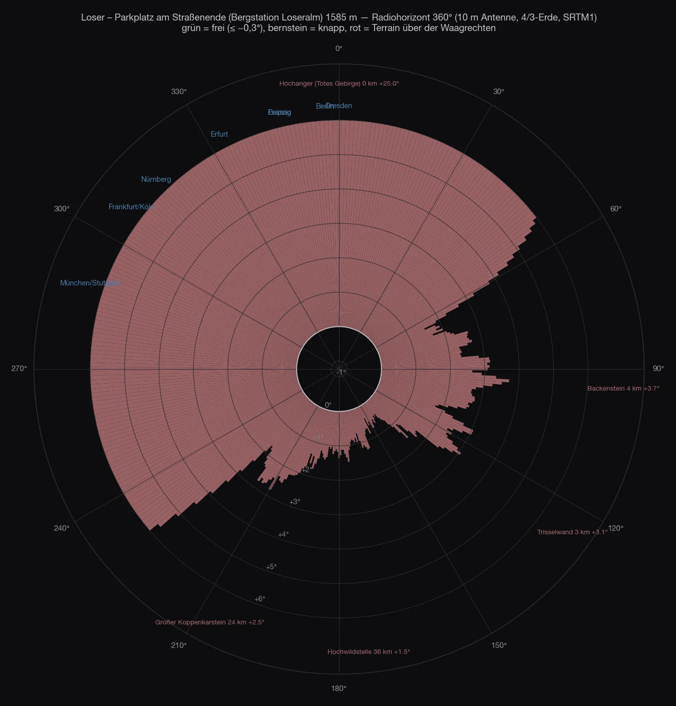
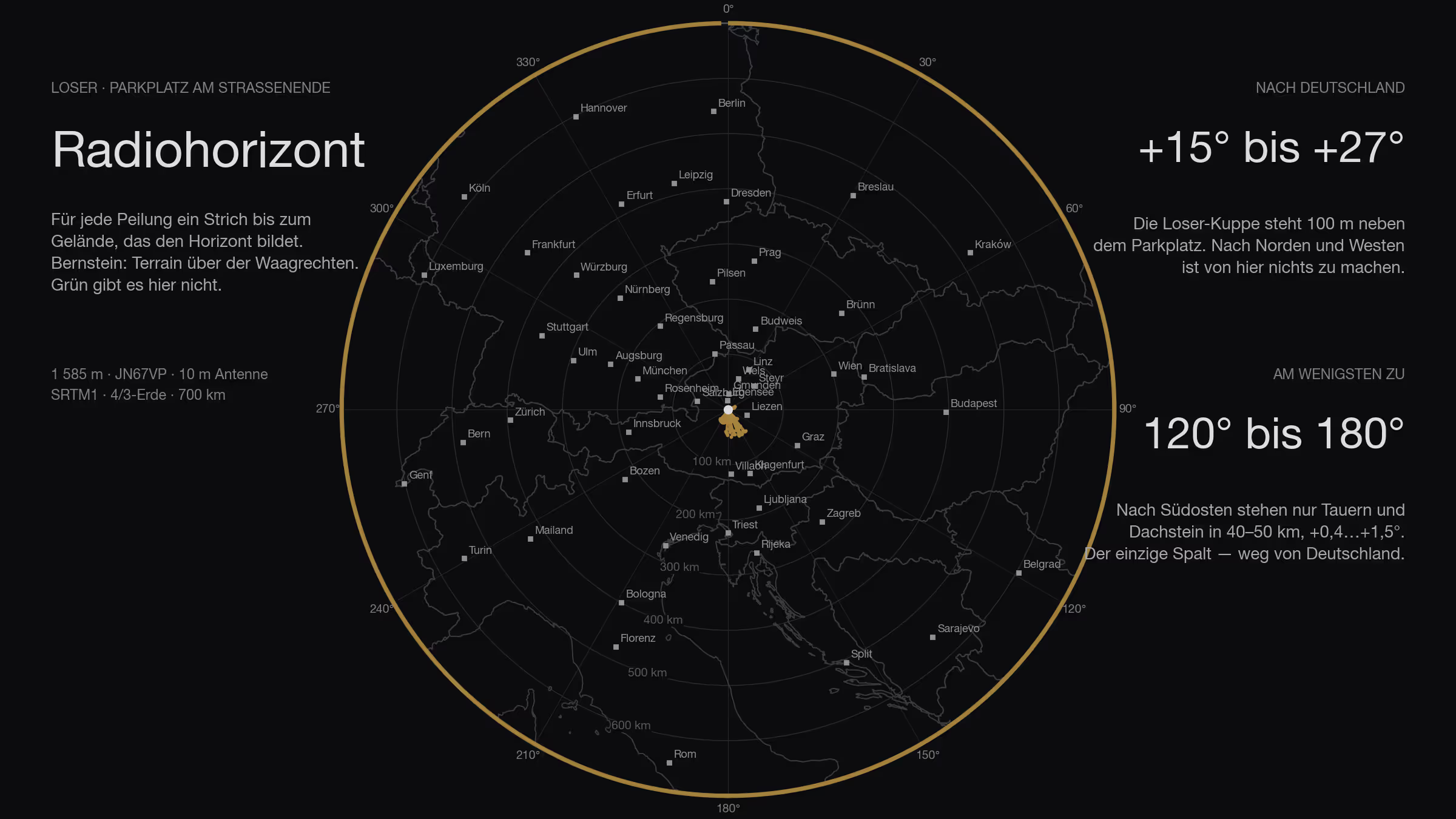
There is no second half. All 360 bearings are closed. The car park sits in a hollow below the Loser summit: to the north and west the ground rises fifty, sixty metres within a hundred — that is +15° to +27° in exactly the direction where Germany lies. To the east the Bräuning Zinken and the Trisselwand, +1.5 to +4°. Only to the south-east, between 120° and 180°, does the horizon come down to +0.4 to +1.5° — there the Tauern and the Dachstein stand forty, fifty kilometres away. That is the direction of Graz and Slovenia, not Nuremberg.
From the Loserhütte car park, eighty metres lower, the picture is the same: 360 bearings closed, towards Germany +15 to +22°, Munich +8.5°, Rosenheim +4.6°.
| Direction | What sets the horizon | Distance | Angle |
|---|---|---|---|
| 240–60° | the Loser summit knoll and the Augstsee saddle right above the car park | 0.1–0.4 km | +4…+27° |
| 60–120° | Bräuning Zinken, Trisselwand | 0.3–4 km | +1.5…+3.8° |
| 120–180° | Wölz Tauern, Sölk pass, Hochwildstelle | 36–50 km | +0.4…+1.5° |
| 180–240° | Elendberg, Koppenkarstein, Dachstein | 22–41 km | +1.0…+2.5° |
The site
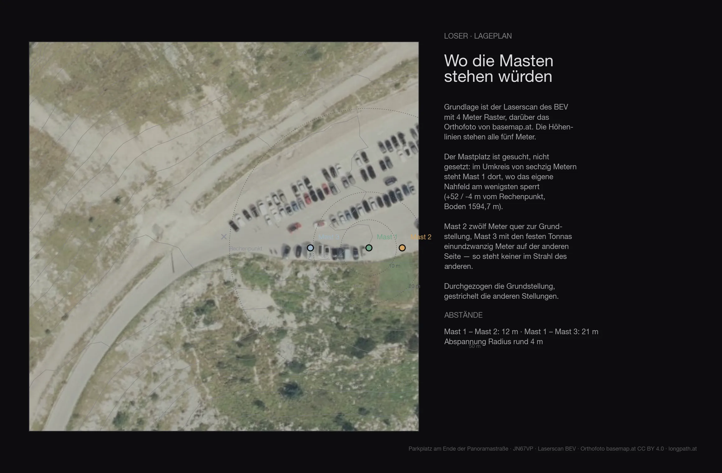
The terrain of the first 136 metres around the site comes from the Austrian lidar survey on a four-metre grid — trees, buildings and knolls included. The ground at the mast is at 1594.7 metres.
| Antenna height | Directions blocked by the near field |
|---|---|
| 6 m | 196° |
| 8 m | 178° |
| 10 m | 164° |
| 12 m | 152° |
| 15 m | 145° |
Even with ten metres of mast the near field still blocks 164 degrees — on top of whatever the far horizon closes off anyway.
The road
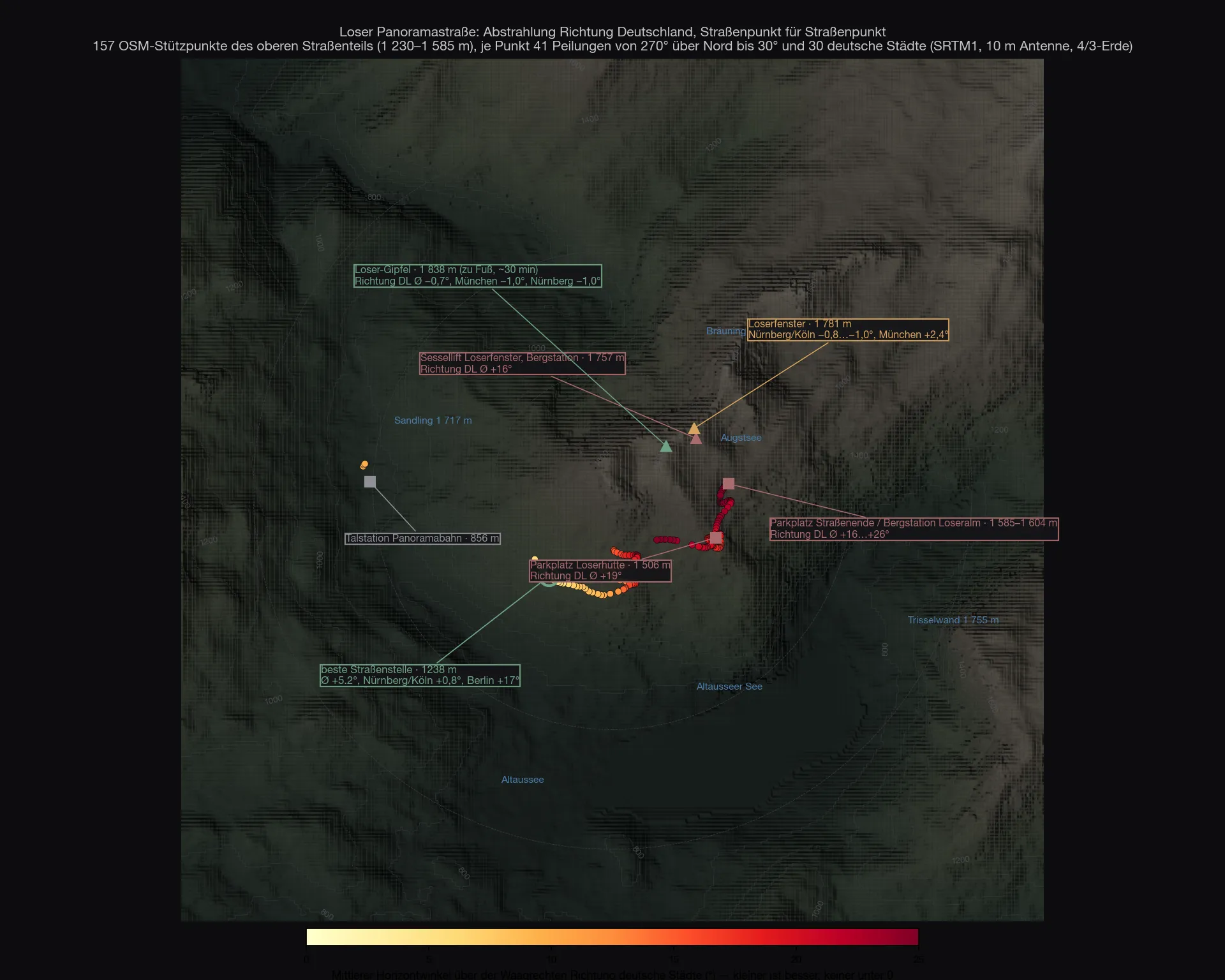
The question was whether anywhere along the road does better. So for 157 road points from OpenStreetMap I calculated 41 bearings each from 270° over north to 30°, plus the angles to thirty German cities. The answer is unambiguous: nowhere. The whole road lies on the south and east flank of the mountain, and the mountain is always to the north. The least bad spot lies at 1,238 metres in the hairpins below the Loserhütte — there Nuremberg and Cologne come down to +0.8°, Munich to +2.7°, Berlin stays at +17°. Still everything above the horizontal.
The top stations
Two lifts end high on the Loser, both just below the ridge. The coordinates of the top stations come from OpenStreetMap, the heights from the terrain model: gondola 47.66137 N / 13.78712 E, chairlift 47.66389 N / 13.78130 E.
The gondola
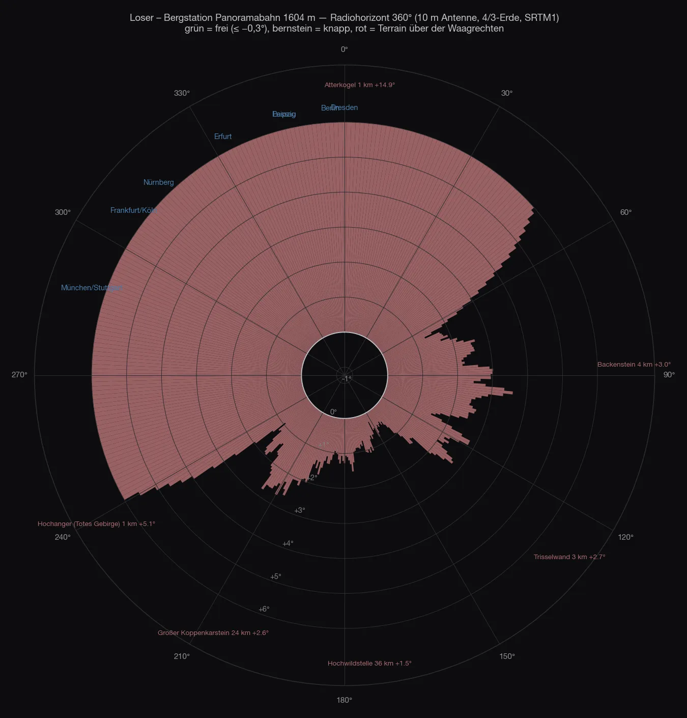
All 360 bearings are closed. The station stands at the foot of the Hochanger ridge that runs east from the Loser summit: to the north and west the ground rises by sixty to two hundred metres within one to seven hundred metres. That is +14° to +19° towards Germany — and Salzburg is just the same, +17°.
| Direction | What sets the horizon | Distance | Angle |
|---|---|---|---|
| 330–60° | Augstsee saddle, Atterkogel | 0.1–1 km | +3…+16° |
| 60–140° | Backenstein, Trisselwand | 0.2–23 km | +1.0…+3.6° |
| 140–200° | Grimming, Kammspitz, Wölz Tauern, Hochwildstelle | 9–54 km | +0.3…+1.7° |
| 200–240° | Dachstein, Sarstein | 0.6–27 km | +0.9…+5.1° |
| 240–330° | the ridge above the Loserhütte, Hochanger | 0.1–1 km | +5.5…+18.8° |
Munich +17.2°, Nuremberg +16.4°, Berlin +14.3°, Prague +12.5°, Linz +10.3°. To the east the Trisselwand does not help either: Vienna +2.2°, Bratislava +2.5°, Budapest +3.0°, Graz +2.5°. Flattest is the south-east, where only the Tauern stand forty, fifty kilometres away — Zagreb +0.7°, Ljubljana +1.1°. Close, but closed.
What does that mean in stations? Within 700 kilometres there are 2,249 contest stations with a log. With a clear horizon the gondola station reaches not a single one of them. If you count generously and include everything up to +0.5° of horizon angle — that is diffraction over the edge, a few decibels, not a wall — it is 22: eleven Slovenes, seven Croats. Up to +1.0° it is 120, almost all in Croatia and Slovenia. Not one German, not one Czech, not one Pole.
The chairlift
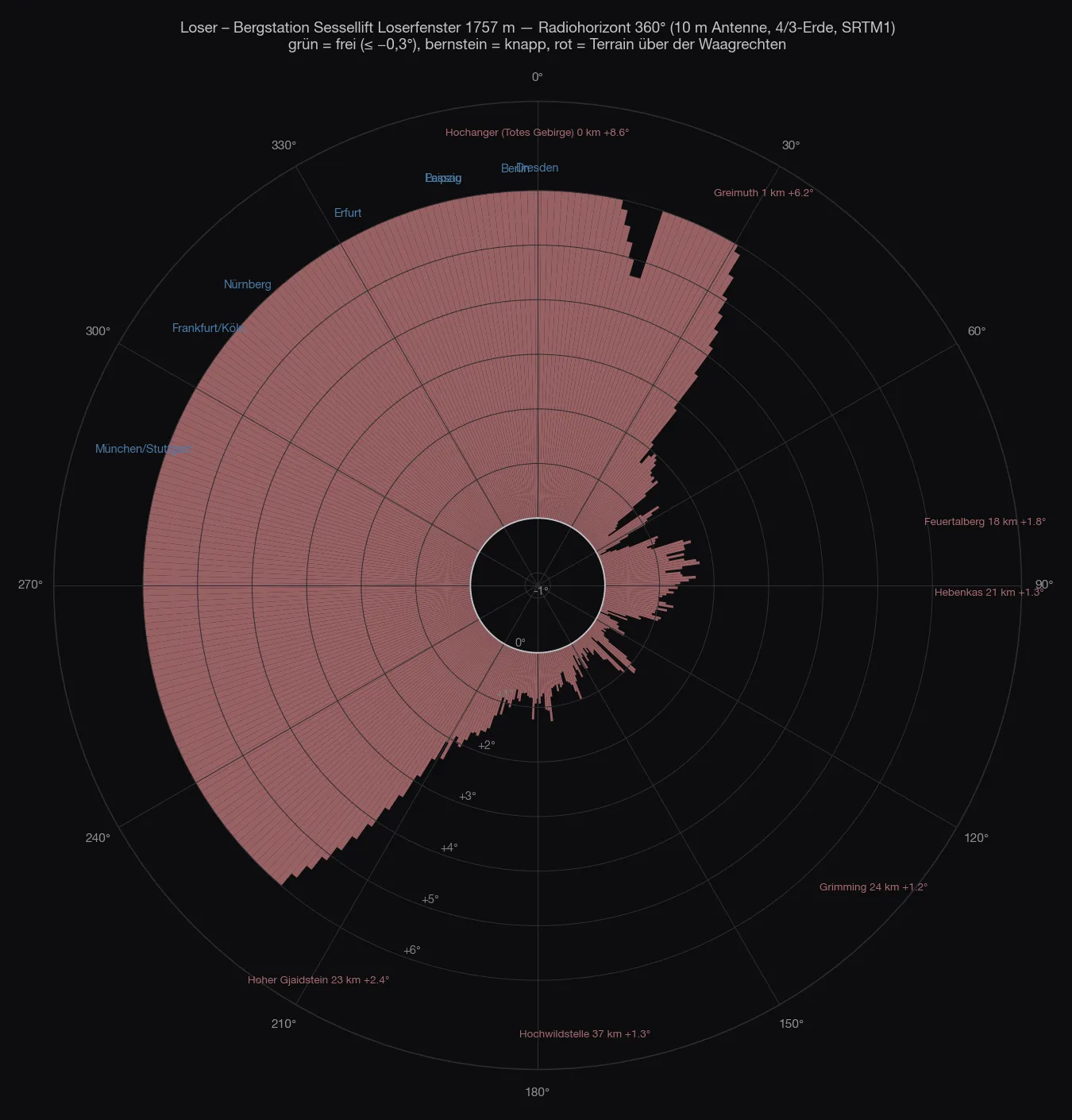
A hundred and fifty metres higher, and to the north nothing changes: the Hochanger stands a hundred metres from the station, +9° to +20°, Munich +20.4°, Nuremberg +18.7°, Berlin +9.2°, Prague +6.6°. The ridge simply has not been overcome yet — that only happens at the summit, another eighty metres of height further up.
What changes is the south-east. From 110° to 170° the horizon lies only +0.1° to +1.0° above the horizontal: Graz +0.4°, Zagreb +0.4°, Ljubljana +0.6°, Vienna +1.0°. Still closed, but so close that it works with diffraction. In stations: with a clear horizon again zero; up to +0.5° then 188 (Croatia 73, Slovenia 29, Slovakia 24); up to +1.0° 436, among them 137 Croats, 65 Italians, 62 Slovenes. That would be, if you want it, a south-east site for the Adriatic region — with a handicap of several decibels in every direction and without a single German log within reach. And whether the chairlift runs in September you have to ask beforehand.
The summit
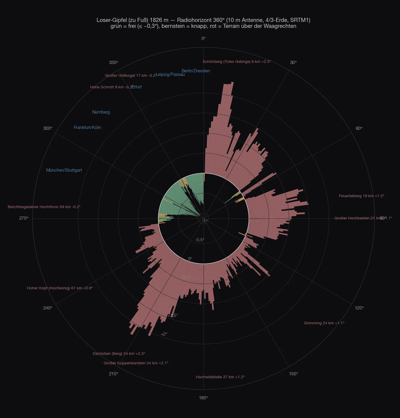
Only at the very top does the picture change. From the Loser summit, 1,838 metres, half an hour on foot from the top station, the ridge is behind you: clear from 269° over north to 359°, −0.3 to −1.0°. Munich −0.97°, Nuremberg −1.02°, Cologne −1.01°, Berlin −0.75°, Passau −0.77°, Dresden −0.77°. Marginal only Rosenheim (−0.55°, behind the Untersberg) and Erfurt (−0.17°, the Großer Höllkogel at 333°). To the north-east the Schönberg closes it (+2.3°), to the south everything else. A north-west site — as good as the Feuerkogel in that direction, but without a car and without a roof.
The Loserfenster at 1,781 metres, a few minutes below the summit, would be the compromise: Nuremberg, Cologne, Berlin clear, Munich at +2.4° behind the ridge.
The four spots on the Loser
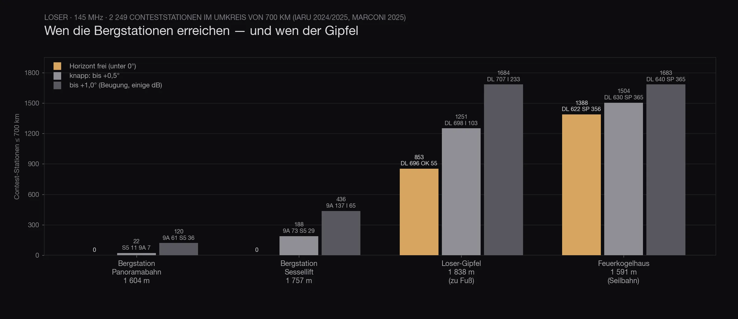
The chart says what the maps say, only in one number. The two top stations: zero. The Loser summit, half an hour on foot above the chairlift: 853 stations with a clear horizon, 696 of them in Germany. And the Feuerkogelhaus, which a cable car also runs up to: 1,388.
The top station that looks at Germany is not on the Loser. It is on the Feuerkogel.
The map
Out to 700 kilometres
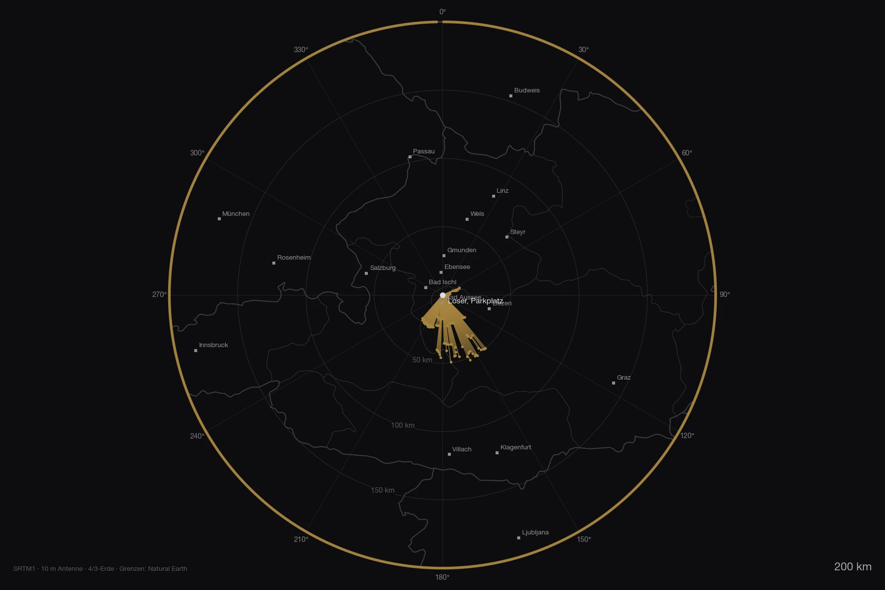
The map shows what the numbers say: the lines from the car park end after a hundred metres to fifty kilometres, however far you pull out the radius. On the overview out to 800 kilometres only the Hochgolling (43 km, 182°, +1.5°) of 78 ranges rises above the horizontal, and it is to the south.
Both maps as PDF: zoom 180 km and overview 800 km.
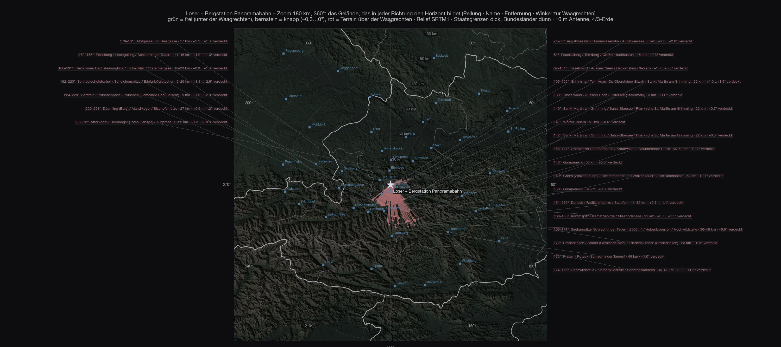
On the zoom you can see how short the lines are: to the north and west they end after a hundred metres, at the ridge above the Loserhütte. Only to the south-east do they reach the Tauern.
Obstructed directions are drawn to at least six percent of the radius so that they can be seen — the real lines would be a hundred metres long. Both maps as PDF: zoom 180 km with the mountain names and overview 800 km with the numbered list — 78 ranges and peaks, of which exactly one, the Hochgolling at 183°, actually rises above the horizontal. All the others have disappeared behind the ridge next to the station before they even count.
The stations
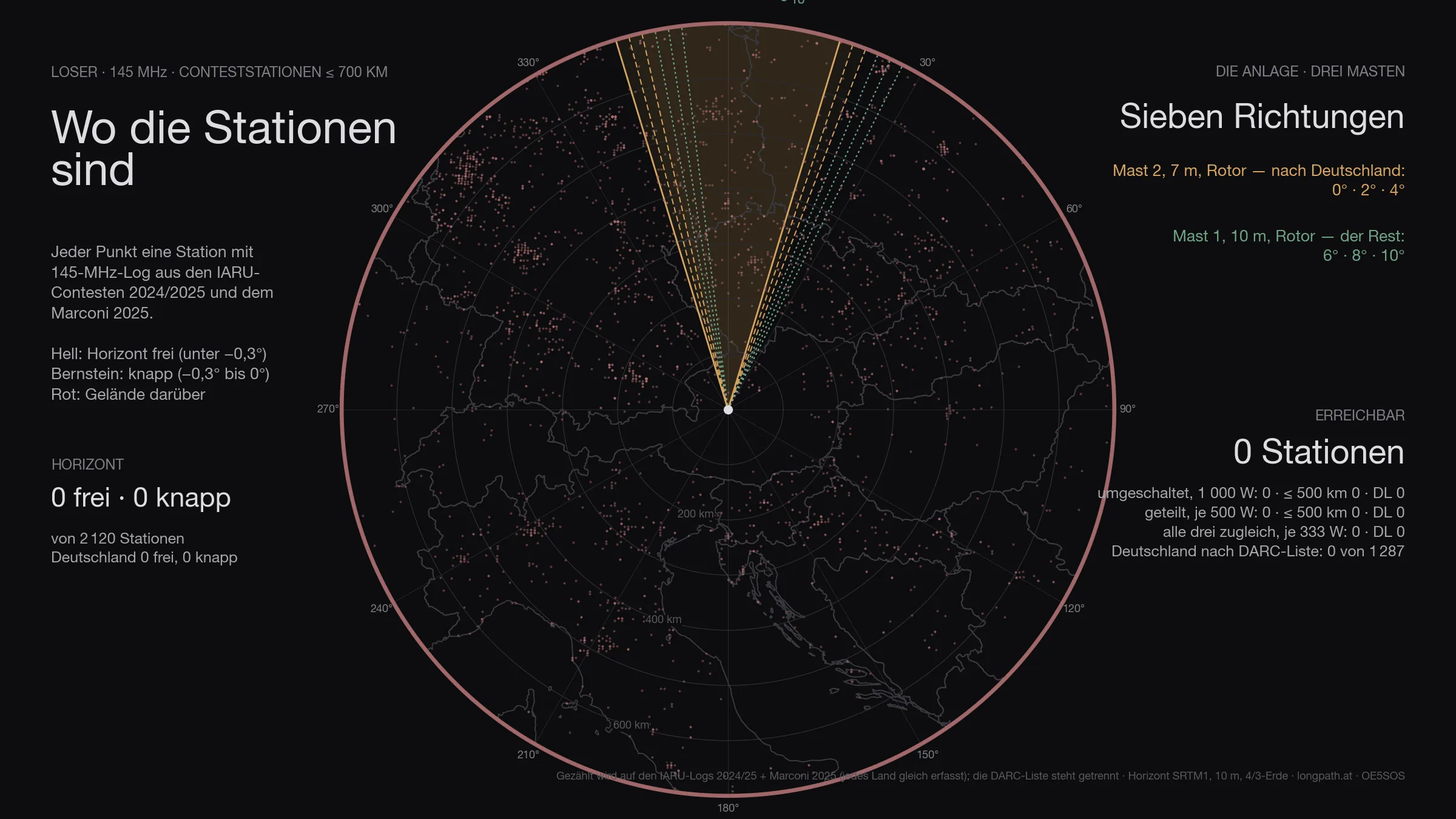
Of the 2 120 stations in the logs, not a single one is above the horizon. That is not a rounding error: in all 360 directions terrain stands above the horizontal.
The antennas
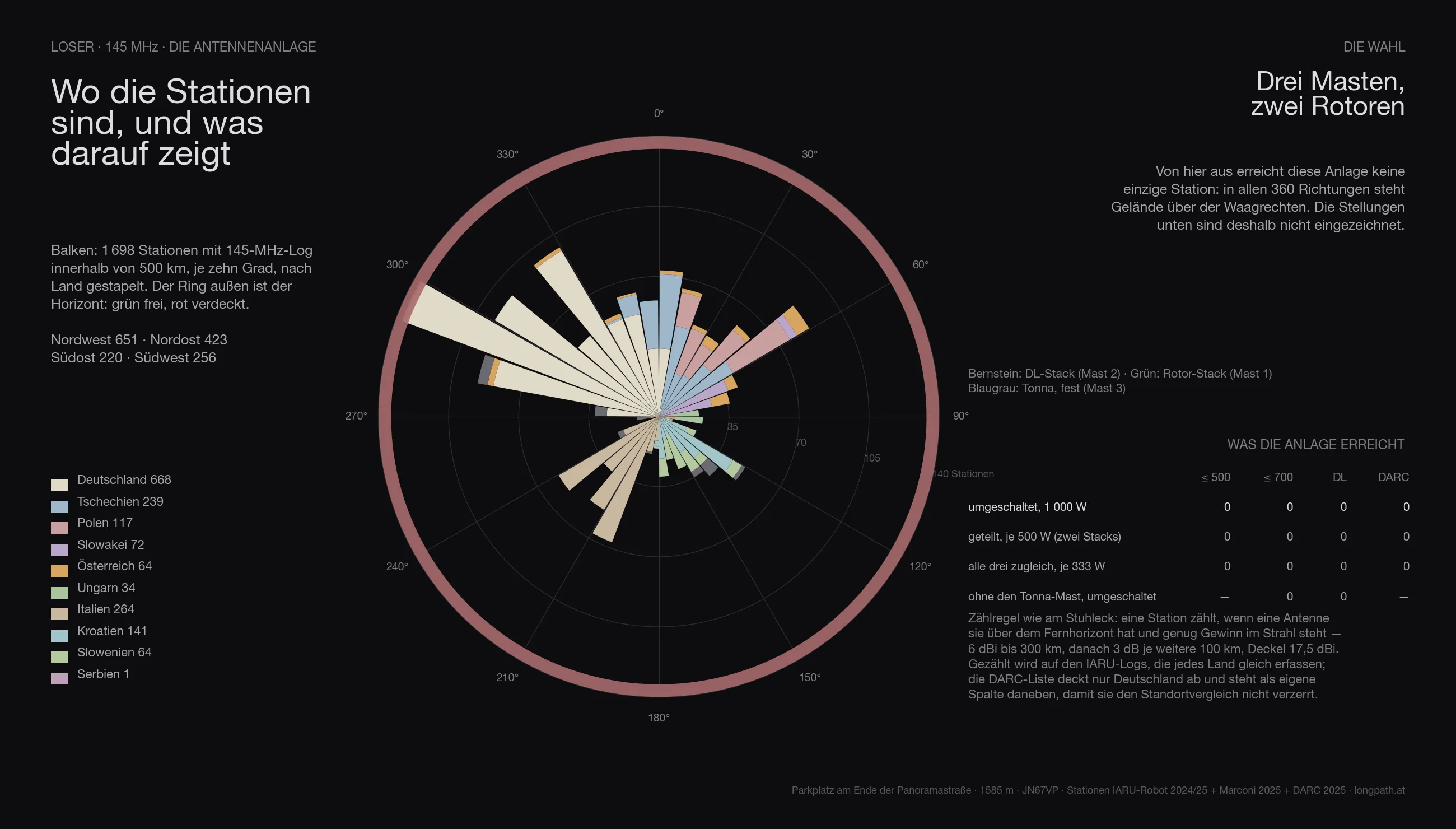
The array that stands on the Stuhleck gets nowhere here: three masts, two rotators, 1 000 watts — and not one station, because the horizon is above the horizontal in every direction. The figure is shown anyway so the comparison stays honest.
In three dimensions
The same view for every site: the terrain comes from the Austrian lidar survey, the orthophoto lies on top, and the two masts stand on it at their computed heights. The labels around the rim are cities — bright means above the horizon, grey means behind it.
The comparison

Every site in this series with the same array, the same counting rule and the same logs — only then are the numbers comparable. Reached means: horizon below the horizontal and enough gain for the distance (6 dBi to 300 km, then 3 dB per further 100 km), with 1 000 watts on whichever system is being worked. Both large antennas sit on rotators — so the count is what is reachable across the whole contest, not what one fixed heading covers.
The count runs on the IARU logs 2024/2025 and the Marconi 2025: they record every country alike. The DARC list covers Germany only — it sits in its own column, otherwise every site that looks west wins on the data alone.
| Site | reached | Germany | DARC list | ≤ 500 km | Access |
|---|---|---|---|---|---|
| Stuhleck · 1 770 m | 1 549 | 326 | 569 | 962 | drive to the top |
| Traisner Hütte · 1 304 m | 1 482 | 569 | 988 | 877 | chairlift, then on foot |
| Grünberg · 989 m | 1 417 | 700 | 1 271 | 826 | cable car, inn |
| Feuerkogelhaus · 1 591 m | 1 302 | 588 | 1 056 | 726 | cable car, inn |
| Braunsberg · 337 m | 1 172 | 454 | 814 | 740 | drive to the top |
| Gaisberg · 1 272 m | 1 055 | 628 | 1 199 | 618 | drive to the top |
| Hochkar · 1 478 m | 438 | 321 | 559 | 247 | drive to the top |
| Loser · 1 585 m | 0 | 0 | 0 | 0 | drive to the top |
Loser therefore comes 8 of 8.
Anyone who knows the earlier articles in this series will find different numbers there: those were computed with the first line-up — one Yagi stack and one quad stack with a 69° beamwidth. Since the choice fell on two narrow 12JXX2 stacks, the order shifts: more gain and less width favours the sites whose stations bunch in one direction, and costs the ones that stand open all round. The fixed Tonnas on mast 3 win part of that width back.
The data
| Site | Loser — Parkplatz am Ende der Panoramastraße |
| Coordinates | 47,66047 N / 13,78493 O · 1 585 m · JN67VP |
| Access | road all the way up |
| Horizon clear | no direction |
| Degrees clear / marginal / blocked | 0° / 0° / 360° |
| Stations ≤ 700 km | 0 clear, 0 marginal, of 2 120 |
| Germany (IARU) | 0 clear, 0 marginal, of 689 |
| Germany (DARC list) | 0 below the horizontal of 1 287 |
| Array | three masts · mast 1 10 m (2 × 12JXX2 at 6.9/9.7 m, rotator) · mast 2 7 m (2 × 12JXX2 at 3.9/6.7 m, rotator) · mast 3 7 m (2 × 9-el Tonna at 3.9/6.7 m, fixed) |
| Headings | — |
| switched · 1 000 W | 0 · ≤ 500 km 0 · DL 0 · with three fixed headings per rotator 0 |
| split · 500 W each | 0 · ≤ 500 km 0 · DL 0 |
| all three at once · 333 W each | 0 · ≤ 500 km 0 · DL 0 |
| without the Tonna mast | 0 instead of 0 |
| Σ kilometres | 0 km |
| strict count | only directions below −0.3°: 0 · ≤ 500 km 0 · DL 0 |
What it means
From the car the Loser is not a contest site — in no direction, least of all towards Germany. The Panoramastraße has no better spot, the lifts end below the ridge. Whoever wants to work north from here carries the station to the summit and gets in return a horizon that lies −0.75 to −1.0° deep from Munich to Dresden. For everything else the Grünberg and the Feuerkogel are the better addresses.
Caveat
A calculation, not a measurement. Especially at close range — the knoll a hundred metres from the car park — the result hangs on the thirty-metre grid of the terrain model; the order of magnitude is right, the single degree is not. Whether there is still a corner of the car park that looks around the knoll is better judged on the spot than in the calculation.
The terrain model has a thirty-metre grid, knows neither the station itself nor the restaurant beside it, and assumes the standard atmosphere. At a site that is +14° closed to the north, none of that changes anything. The station counts are logs, not stations, and two years old.
73 · OE5SOS